IMAGES TAKEN NEAR TO
Ferry Street, LONDON, E14 3DS
Introduction
This page details the photographs taken nearby to Ferry Street, E14 3DS by members of the Geograph project.
The Geograph project started in 2005 with the aim of publishing, organising and preserving representative images for every square kilometre of Great Britain, Ireland and the Isle of Man.

There are currently over 7.5m images from over14,400 individuals and you can help contribute to the project by visiting https://www.geograph.org.uk
Image Map
Images are licensed for reuse under creativecommons.org/licenses/by-sa/2.0
Notes
- Clicking on the map will re-center to the selected point.
- The higher the marker number, the further away the image location is from the centre of the postcode.
Image Listing (449 Images Found)
Images are licensed for reuse under creativecommons.org/licenses/by-sa/2.0
Image
Details
Distance
1
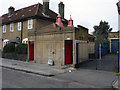
Manchester road
Public toilet on Manchester road, Isle of dogs.
Image: © geo sharples
Taken: 11 Feb 1999
0.01 miles
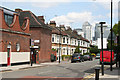
2
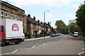
Isle of Dogs: Manchester Road
Looking east from the end of Manchester Road, where it meets East Ferry Road and Westferry Road at the 'Lord Nelson'
Image: © Dr Neil Clifton
Taken: 14 Jun 2012
0.02 miles
4
Isle of Dogs: The 'Lord Nelson'
At the junction of Manchester Road with East Ferry Road
Image: © Dr Neil Clifton
Taken: 14 Jun 2012
0.04 miles
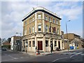
6
The Lord Nelson, Manchester Road (closed)
Last recorded as open in 2014 Image The road closure and ice-cream van were due to the London Marathon passing just out of shot to the left.
Image: © Stephen Craven
Taken: 28 Apr 2019
0.05 miles
7
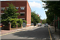
Isle of Dogs: Felstead Wharf
Looking east
Image: © Dr Neil Clifton
Taken: 14 Jun 2012
0.05 miles
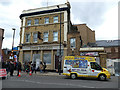
8
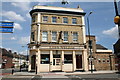
Fire Brigade Station, Millwall
Former fire station now converted to a bar.
Image: © Chris Whippet
Taken: 10 Sep 2014
0.06 miles
9
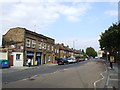
Isle of Dogs: East Ferry Road
Looking north from its junction with Manchester Road, at the 'Lord Nelson'. It is interesting to note that, on road signs and elsewhere, this road always has the 'East' and the 'Ferry' as two separate words, with a space between them, whereas the nearby Westferry Road does not get a space!
Image: © Dr Neil Clifton
Taken: 14 Jun 2012
0.06 miles
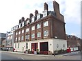
10
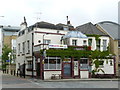
The Ferry House Public House
Dates from c1722.
http://www.ferryhousee14.co.uk/
Image: © Peter Trimming
Taken: 7 May 2009
0.06 miles