IMAGES TAKEN NEAR TO
Manchester Road, LONDON, E14 3DH
Introduction
This page details the photographs taken nearby to Manchester Road, E14 3DH by members of the Geograph project.
The Geograph project started in 2005 with the aim of publishing, organising and preserving representative images for every square kilometre of Great Britain, Ireland and the Isle of Man.

There are currently over 7.5m images from over14,400 individuals and you can help contribute to the project by visiting https://www.geograph.org.uk
Image Map
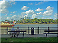
Images are licensed for reuse under creativecommons.org/licenses/by-sa/2.0
Notes
- Clicking on the map will re-center to the selected point.
- The higher the marker number, the further away the image location is from the centre of the postcode.
Image Listing (304 Images Found)
Images are licensed for reuse under creativecommons.org/licenses/by-sa/2.0
Image
Details
Distance
1
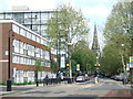
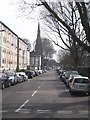
Cubitt Town: Christ Church
One of two churches on the Isle of Dogs this one was built using his own funds by William Cubitt between 1852 and 1854. Cubitt was responsible for much of the development of the south-east corner of the Isle of Dogs. The road is the A1206 Manchester Road.
Image: © Nigel Cox
Taken: 1 May 2008
0.02 miles
2
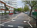
Manchester Road, E14
Looking east from opposite Island Gardens Station.
Image: © Malc McDonald
Taken: 1 May 2010
0.03 miles
3
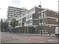
Shops on Manchester Road
This row of shops near the junction with Glengarnock Avenue included (as of 2010) a dry cleaner, newsagent, bookmaker and pharmacy.
Image: © Stephen Craven
Taken: 29 Jul 2010
0.05 miles
4
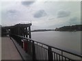
View of housing on the Isle of Dogs from Ballast Quay
Looking north-northeast.
Image: © Robert Lamb
Taken: 8 Jul 2010
0.05 miles
5
Glengarnock Avenue Millwall
At the end of the road is Christ Church, built by William Cubitt in 1852-54.
Image: © Rod Allday
Taken: 20 Mar 2011
0.05 miles
6
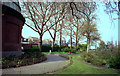
Island Gardens, Millwall
Looking through the plane trees, the original Island Gardens station of the Docklands Light Railway can be seen. This station is now demolished and replaced by one underground, so that the trains can use the new tunnel to Greenwich and Lewisham.
Image: © Dr Neil Clifton
Taken: 10 Apr 1991
0.06 miles
7
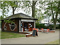
Island Garden Caf
I can imagine this being a popular location at weekends. However, on a cool May week-day, the café appeared almost deserted.
Image: © Peter Trimming
Taken: 7 May 2009
0.06 miles
8
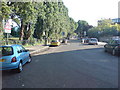
Stebondale Street, E14
Near Manchester Road. Millwall Park is on the left.
Image: © Danny P Robinson
Taken: 16 Jun 2009
0.07 miles
9
View of the Isle of Dogs and Canary Wharf from Greenwich
Image: © Jim Osley
Taken: 11 Sep 2011
0.07 miles
10
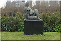
Turf Zone "MillwallPark"
Women and Fish sculpture in Millwall Park, Isle of Dogs, London.
Image: © Ian S
Taken: 25 Dec 2022
0.07 miles