IMAGES TAKEN NEAR TO
Newport Avenue, LONDON, E14 2DN
Introduction
This page details the photographs taken nearby to Newport Avenue, E14 2DN by members of the Geograph project.
The Geograph project started in 2005 with the aim of publishing, organising and preserving representative images for every square kilometre of Great Britain, Ireland and the Isle of Man.

There are currently over 7.5m images from over14,400 individuals and you can help contribute to the project by visiting https://www.geograph.org.uk
Image Map
Images are licensed for reuse under creativecommons.org/licenses/by-sa/2.0
Notes
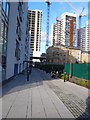
- Clicking on the map will re-center to the selected point.
- The higher the marker number, the further away the image location is from the centre of the postcode.
Image Listing (271 Images Found)
Images are licensed for reuse under creativecommons.org/licenses/by-sa/2.0
Image
Details
Distance
2
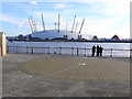
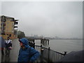
View across Prime Meridian and River Thames towards Millennium Dome
This was taken from the north bank of the river looking SSE. The prime meridian runs across the foreground and is marked by a strip of metal in the pavement. The photographer was in the western hemisphere and the three people in the photo are in the eastern hemisphere
Image: © Nigel Mykura
Taken: 12 Jan 2008
0.04 miles
3
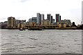
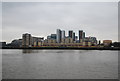
Apartments overlooking the River Thames
The apartments closest to the river are on Jamestown Way.
Image: © Steve Daniels
Taken: 6 Sep 2013
0.04 miles
5
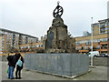
Virginia Settlers Monument, Blackwall
A plaque of 1928 on a stone pile of 1951 with the upper and lower parts added in 1999 when the area was redeveloped and the monument moved nearly 100 m east. Grade II listed. It commemorates the departure of settlers in North America from Blackwall Quay in 1606.
Image: © Robin Webster
Taken: 29 Jan 2011
0.05 miles
6
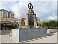
Virginia Quay Monument
http://www.pastscape.org.uk/hob.aspx?hob_id=1506643
Image: © Chris Whippet
Taken: 14 Sep 2014
0.05 miles
7
View of Trinity Buoy Wharf and the Emirates Air Line from Virginia Wharf
Looking east-northeast.
Image: © Robert Lamb
Taken: 8 Oct 2012
0.06 miles
8
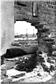
Two Power Stations, 1974
An unusual view of Brunswick Wharf (Blackwall) and West Ham Image power stations through a hole in a dock wall, off Blackwall Way
Image: © Pierre Terre
Taken: Unknown
0.06 miles
9
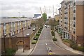
Housing Construction and Prime Meridian, London
This shows high rise apartments being built close to the river Thames in Blackwall , east London. On the pavement the prime meridian is marked with a checkerboard of small tiles and a brass strip. A blue line of tiles has also been put on the low rise white building in the middle distance to mark the meridian. This view is due north along the meridian.
Image: © Nigel Mykura
Taken: 12 Jan 2008
0.06 miles
10

Brunswick Power Station, Blackwall
As seen from a pleasure-boat on the Essex shore of the Thames. It is large and impressive, but it operated only from 1952 until 1984, using coal until 1971, then oil. It is situated at the confluence of the River Lea with the Thames, also on the Greenwich Meridian.
Image: © Ben Brooksbank
Taken: 25 Aug 1955
0.07 miles