IMAGES TAKEN NEAR TO
Mercury Walk, LONDON, E14 0UT
Introduction
This page details the photographs taken nearby to Mercury Walk, E14 0UT by members of the Geograph project.
The Geograph project started in 2005 with the aim of publishing, organising and preserving representative images for every square kilometre of Great Britain, Ireland and the Isle of Man.

There are currently over 7.5m images from over14,400 individuals and you can help contribute to the project by visiting https://www.geograph.org.uk
Image Map
Images are licensed for reuse under creativecommons.org/licenses/by-sa/2.0
Notes
- Clicking on the map will re-center to the selected point.
- The higher the marker number, the further away the image location is from the centre of the postcode.
Image Listing (239 Images Found)
Images are licensed for reuse under creativecommons.org/licenses/by-sa/2.0
Image
Details
Distance
1
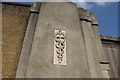
View of an emblem on the Old East India Dock Yard wall on Leamouth Road
Looking east-northeast.
Image: © Robert Lamb
Taken: 5 Jun 2016
0.02 miles
2
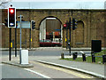
A hole in the wall, E14
The old East India Dock wall is pierced by a pedestrian way. Leamouth Road is now a dual carriageway on each side of the wall, formerly it was only on the far side. This opening appears to be an old dock gate allowing easy road transfer to the former railway depot (GER) immediately across the road.
Image: © Robin Webster
Taken: 5 Feb 2011
0.03 miles
4
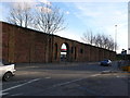
Old Dock Yard Wall, Leamouth Rd East London
This is part of the old wall that used to surround the East India Docks to protect the goods that had been landed from the ships. Most of the docks and most of the wall have now gone but this impressive part remains.
Image: © Nigel Mykura
Taken: 12 Jan 2008
0.04 miles
7
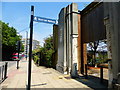
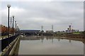
View of Canary Wharf from the Bow Creek Ecology Park path #2
Looking southwest over the DLR tracks.
Image: © Robert Lamb
Taken: 8 May 2011
0.06 miles
8
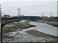
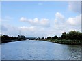
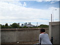
Bow Creek
Looking upstream. At low tide the creek assumes a significant downstream flow - what is left of the waters of the River Lea after waterworks extraction.
Image: © Robin Webster
Taken: 29 Jan 2011
0.07 miles
9
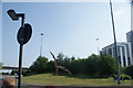
View of a sculpture in the middle of the roundabout at Leamouth
Looking south-southeast.
Image: © Robert Lamb
Taken: 5 Jun 2016
0.07 miles
10
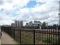
View of Canary Wharf from the A13
Looking southwest.
Image: © Robert Lamb
Taken: 8 May 2011
0.07 miles