IMAGES TAKEN NEAR TO
Lyell Street, LONDON, E14 0SU
Introduction
This page details the photographs taken nearby to Lyell Street, E14 0SU by members of the Geograph project.
The Geograph project started in 2005 with the aim of publishing, organising and preserving representative images for every square kilometre of Great Britain, Ireland and the Isle of Man.

There are currently over 7.5m images from over14,400 individuals and you can help contribute to the project by visiting https://www.geograph.org.uk
Image Map
Images are licensed for reuse under creativecommons.org/licenses/by-sa/2.0
Notes
- Clicking on the map will re-center to the selected point.
- The higher the marker number, the further away the image location is from the centre of the postcode.
Image Listing (364 Images Found)
Images are licensed for reuse under creativecommons.org/licenses/by-sa/2.0
Image
Details
Distance
1
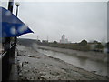
View of the Lea from the Bow Creek footpath
Looking north-northeast.
Image: © Robert Lamb
Taken: 8 Oct 2012
0.01 miles
2
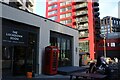
View of a red telephone box in front of The Lockdown Room bar on City Island
Looking south-southeast.
Image: © Robert Lamb
Taken: 2 Jul 2024
0.02 miles
3

Buildings around Hopewell Square on London City Island
Image: © Tom Page
Taken: 21 Sep 2021
0.02 miles
4
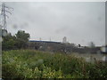
View of the old railway bridge and new footbridge from Bow Creek footpath
Looking north-northeast.
Image: © Robert Lamb
Taken: 8 Oct 2012
0.02 miles
5
Development alongside the Lower Lea Crossing
Looking west-southwest across the DLR and River Lea.
Image: © Robert Lamb
Taken: 8 May 2011
0.03 miles
6
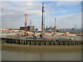
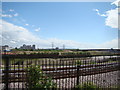
Leamouth Peninsula
The former Pura Foods margarine factory has been demolished and construction work has commenced on redeveloping Orchard Place for residential, retail and educational use. Amongst the plans are proposals to build a new bridge over the River Lee to connect the peninsula to Canning Town. Canning Town DLR station with a stationary train is to the left, while the River Lee is in the foreground, flowing downstream here from right to left. The Sphere is the large dark orange building middle left. The machinery on the construction site is for installing concrete piles on which the new buildings will be based.
On the OS mapping for 1869 and 1882 this site is shown occupied by the Thames Plate Glass Works, but by 1898 it was shown as Cooperage Wharf.
Image: © Nigel Cox
Taken: 5 Mar 2008
0.03 miles
7
Offices on the Leamouth Peninsula, Canning Town
From the A13 East India Dock Road
Image: © David Howard
Taken: 22 Jan 2023
0.03 miles
8

View of an otter statue in the garden area in City Island
Looking north-northwest.
Image: © Robert Lamb
Taken: 2 Jul 2024
0.03 miles
9
View of a statue of ballet shoes on City Island
Looking south-southeast.
Image: © Robert Lamb
Taken: 2 Jul 2024
0.03 miles
10

View of Bridgewater, Corson, Defoe and Amelia Houses in City Island
Looking south-southeast.
Image: © Robert Lamb
Taken: 2 Jul 2024
0.03 miles