IMAGES TAKEN NEAR TO
Brion Place, LONDON, E14 0SP
Introduction
This page details the photographs taken nearby to Brion Place, E14 0SP by members of the Geograph project.
The Geograph project started in 2005 with the aim of publishing, organising and preserving representative images for every square kilometre of Great Britain, Ireland and the Isle of Man.

There are currently over 7.5m images from over14,400 individuals and you can help contribute to the project by visiting https://www.geograph.org.uk
Image Map
Images are licensed for reuse under creativecommons.org/licenses/by-sa/2.0
Notes
- Clicking on the map will re-center to the selected point.
- The higher the marker number, the further away the image location is from the centre of the postcode.
Image Listing (110 Images Found)
Images are licensed for reuse under creativecommons.org/licenses/by-sa/2.0
Image
Details
Distance
1
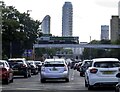
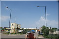
Blackwall Tunnel Northern Approach (A12)
Image: © Steve Daniels
Taken: 1 Oct 2022
0.04 miles
2
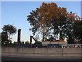
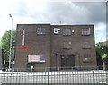
Poplar Works construction
A new work space is being built on what the map says is the site of a former school.
Image: © David Howard
Taken: 19 Oct 2019
0.06 miles
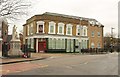
3
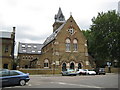
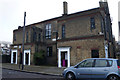
Bromley: The former church of St Michael and All Angels
The building dates from 1867 and was a church within the parish of St Leonard Bromley, being built on the east side of St Leonard's Road. It survived the Blitz but was closed in 1975, and has since been converted into residential use. It is now known as St Michael Court.
Image: © Nigel Cox
Taken: 19 Aug 2008
0.06 miles
4
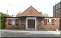
Poplar Baptist Church, Zetland Street, London E14
Built 1950. More at this http://www.religionandplace.org.uk/religionandplace/explore_poplar_baptist.php.
Image: © Jim Osley
Taken: 24 Apr 2015
0.07 miles
5
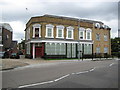
Bromley: Former St Leonard's public house
This is another former Victorian public house that survived the Blitz but presumably succumbed to the fall-off in trade when all the surrounding houses were demolished after the war. It is on St Leonard's Road immediately to the south of Image, and opposite Image The attached house on the right appears to be an unsympathetic later addition.
Image: © Nigel Cox
Taken: 19 Aug 2008
0.07 miles
6
Poplar Baptist Church
The Poplar and Berger Tabernacle on the junction of Zetland Street (on the left) and the A12 Blackwall Approach Road (dual carriageway) in front.
Image: © David Anstiss
Taken: 13 Jul 2012
0.07 miles
8
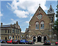
Former St Michael and All Angels and Vicarage, St Leonard's Road
Gothic church with polychromatic brick, large circular, traceried window, and tower with pyramidal roof. By R.W. Morris, 1864-65. Grade II listed.
Facing it is the former vicarage with a pair of symmetrical gables.
All this is 'former' because it has been converted into flats, a fact to warm the cockles of any atheist's heart.
Image: © Stephen Richards
Taken: 4 Jun 2011
0.08 miles
9
View of industrial land from Lochnagar Street
Looking east.
Image: © Robert Lamb
Taken: 5 Jun 2016
0.08 miles
10
The former St Leonards Arms
The former pub at the junction of Spey Street and St Leonards Road. http://deadpubs.co.uk/LondonPubs/Bromley/StLeonardsArms.shtml provides some photographs and history. The pub closed in 1999 and became flats three years later.
On the left is a war memorial, described at http://exploringeastlondon.co.uk/eel/Poplar/Poplar.htm#Warmemorial .
Image: © Derek Harper
Taken: 12 Jan 2011
0.08 miles