IMAGES TAKEN NEAR TO
Benledi Road, LONDON, E14 0NR
Introduction
This page details the photographs taken nearby to Benledi Road, E14 0NR by members of the Geograph project.
The Geograph project started in 2005 with the aim of publishing, organising and preserving representative images for every square kilometre of Great Britain, Ireland and the Isle of Man.

There are currently over 7.5m images from over14,400 individuals and you can help contribute to the project by visiting https://www.geograph.org.uk
Image Map
Images are licensed for reuse under creativecommons.org/licenses/by-sa/2.0
Notes
- Clicking on the map will re-center to the selected point.
- The higher the marker number, the further away the image location is from the centre of the postcode.
Image Listing (96 Images Found)
Images are licensed for reuse under creativecommons.org/licenses/by-sa/2.0
Image
Details
Distance
1
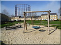
Former gas works from park next to Benledi Street
The aim of the Council is to eventually decommission and remove the gas holders seen here. They are located in Leven Road, adjacent to the River Lea. This view is from a small, well-kept park situated in a triangle between Benledi Road, Blair Street and Abbott Road.
Image: © Marathon
Taken: 5 Mar 2014
0.02 miles
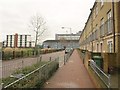
2
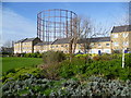
Former gas works looking across Abbott Road
The aim of the Council is to eventually decommission and remove the gas holders seen here. They are located in Leven Road, adjacent to the River Lea. This view is from a small, well-kept park situated in a triangle between Benledi Road, Blair Street and Abbott Road. The houses are in Abbott Road.
Image: © Marathon
Taken: 5 Mar 2014
0.03 miles
3
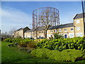
Former gas works looking across Abbott Road
The aim of the Council is to eventually decommission and remove the gas holders seen here. They are located in Leven Road, adjacent to the River Lea. This view is from a small, well-kept park situated in a triangle between Benledi Road, Blair Street and Abbott Road. The houses are in Abbott Road.
Image: © Marathon
Taken: 5 Mar 2014
0.03 miles
4
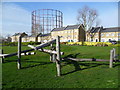
Former gas works looking across Abbott Road
The aim of the Council is to eventually decommission and remove the gas holders seen here. They are located in Leven Road, adjacent to the River Lea. This view is from a small, well-kept park situated in a triangle between Benledi Road, Blair Street and Abbott Road. The houses are in Abbott Road.
Image: © Marathon
Taken: 5 Mar 2014
0.03 miles
5
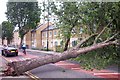
Fallen Tree Abbott Road June 2004
Disturbed by recent demolition work behind the tree and the fact that it was now exposed to the wind and surrounded by tarmac, it just fell one day onto the new houses on Abbott Road, blocking the B125, busy A13 cut-through for hours.
Image: © Steve Kentfield
Taken: 23 Jun 2004
0.04 miles
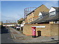
6
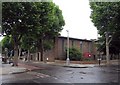
Benledi Road, E14
Seen from its junction with Abbott Road. The block of flats on the left is Blairgowrie Court, on Blair Road.
Image: © Derek Harper
Taken: 12 Jan 2011
0.04 miles
7
Looking down Goodway Gardens, Poplar
The gas holders are located in Leven Road, adjacent to the River Lea. The aim of the Council is to eventually decommission and remove the gas holders but at the moment they still make an attractive background to an otherwise nondescript street.
Image: © Marathon
Taken: 5 Mar 2014
0.04 miles
8
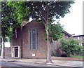
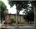
St Nicholas & All Hallows, Aberfeldy Street, London E14
Image: © John Salmon
Taken: 24 Jun 2007
0.07 miles
9
St Nicholas & All Hallows, Aberfeldy Street, London E14
Image: © John Salmon
Taken: 24 Jun 2007
0.07 miles
10
St Nicholas & All Hallows, Aberfeldy Street, London E14
Image: © John Salmon
Taken: 24 Jun 2007
0.07 miles