IMAGES TAKEN NEAR TO
New Village Avenue, LONDON, E14 0GN
Introduction
This page details the photographs taken nearby to New Village Avenue, E14 0GN by members of the Geograph project.
The Geograph project started in 2005 with the aim of publishing, organising and preserving representative images for every square kilometre of Great Britain, Ireland and the Isle of Man.

There are currently over 7.5m images from over14,400 individuals and you can help contribute to the project by visiting https://www.geograph.org.uk
Image Map (Loading...)


Getting Data...Please wait
Leaflet Map data © OpenStreetMap
Images are licensed for reuse under creativecommons.org/licenses/by-sa/2.0
Notes
- Clicking on the map will re-center to the selected point.
- The higher the marker number, the further away the image location is from the centre of the postcode.
Image Listing (175 Images Found)
Images are licensed for reuse under creativecommons.org/licenses/by-sa/2.0
Image
Details
Distance
1

Tower block on East India Dock Road, Poplar
Image: © David Howard
Taken: 22 Jan 2023
0.03 miles
2
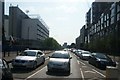
View along East India Dock Road
Looking west.
Image: © Robert Lamb
Taken: 5 Jun 2016
0.04 miles
3
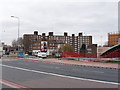
Flats in South Bromley, London Docklands
The flats are between east India Dock Road and Abbott Road. View west, with gasholders on the right of the photo.
Image: © David Hawgood
Taken: 21 Mar 2006
0.05 miles
4
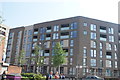
View of the new Aberfeldy Village apartments from Oban Street
Looking south-southwest across Abbott Road.
Image: © Robert Lamb
Taken: 5 Jun 2016
0.05 miles
5
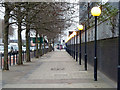
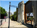
Row of bollards, row of trees, row of lamps
The pavement along East India Dock Road, the A13.
Image: © Robin Webster
Taken: 5 Feb 2011
0.07 miles
6
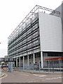
Computer centre, Coriander Avenue. South Bromley
View west from Oregano Drive. The Telehouse Europe website http://www.telehouse.net/ tells us they house computers and telecommunications facilities for a number of customers. Their page for this London Docklands location http://www.telehouse.net/en/global-locations/uk describes the facilities and gives another photograph.
Image: © David Hawgood
Taken: 21 Mar 2006
0.07 miles
7
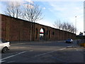
Old Dock Yard Wall, Leamouth Rd East London
This is part of the old wall that used to surround the East India Docks to protect the goods that had been landed from the ships. Most of the docks and most of the wall have now gone but this impressive part remains.
Image: © Nigel Mykura
Taken: 12 Jan 2008
0.09 miles
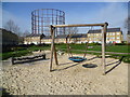
9
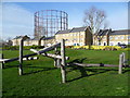
Former gas works looking across Abbott Road
The aim of the Council is to eventually decommission and remove the gas holders seen here. They are located in Leven Road, adjacent to the River Lea. This view is from a small, well-kept park situated in a triangle between Benledi Road, Blair Street and Abbott Road. The houses are in Abbott Road.
Image: © Marathon
Taken: 5 Mar 2014
0.09 miles
10
Former gas works from park next to Benledi Street
The aim of the Council is to eventually decommission and remove the gas holders seen here. They are located in Leven Road, adjacent to the River Lea. This view is from a small, well-kept park situated in a triangle between Benledi Road, Blair Street and Abbott Road.
Image: © Marathon
Taken: 5 Mar 2014
0.09 miles