IMAGES TAKEN NEAR TO
Simpsons Road, LONDON, E14 0AN
Introduction
This page details the photographs taken nearby to Simpsons Road, E14 0AN by members of the Geograph project.
The Geograph project started in 2005 with the aim of publishing, organising and preserving representative images for every square kilometre of Great Britain, Ireland and the Isle of Man.

There are currently over 7.5m images from over14,400 individuals and you can help contribute to the project by visiting https://www.geograph.org.uk
Image Map
Images are licensed for reuse under creativecommons.org/licenses/by-sa/2.0
Notes
- Clicking on the map will re-center to the selected point.
- The higher the marker number, the further away the image location is from the centre of the postcode.
Image Listing (344 Images Found)
Images are licensed for reuse under creativecommons.org/licenses/by-sa/2.0
Image
Details
Distance
1
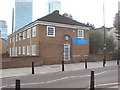
Vietnamese Pastoral Centre, 130 Poplar High Street, London, E14 0AG
This is for Vietnamese Christians locally. At some times of year, this building is quite literally in the shadow of the office blocks behind.
Image: © Danny P Robinson
Taken: 16 Sep 2009
0.04 miles
2
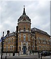
Former Poplar Board of Works, Poplar High Street
A splendid piece of Victorian polychromy. In an Italian Gothic style by Hills and Fletcher with A. and C. Harston in 1869-70. The tower in particular is a lovely touch with its spired dome, rich carvings and decorative frieze. Grade II listed.
At the time of the photo, the building appeared to be disused, although, externally at least, it seemed to be in reasonable condition.
Image: © Stephen Richards
Taken: Unknown
0.04 miles
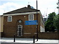
3
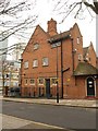
Coroner's Court, E14
Fronting onto Poplar High Street, but seen here from Cottage Street, and dating from 1910 http://www.britishlistedbuildings.co.uk/en-206181-3-piers-immediately-in-front-of-no-127-p (which gives the initial impression that just the piers, one of which can be seen on the left, at the front of the building, are listed, rather than the building itself).
Image: © Derek Harper
Taken: 2 Feb 2011
0.04 miles
4
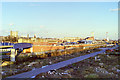
View from West India Quay station, 1987
Looking roughly east towards the DLR depot at Poplar.
Image: © Robin Webster
Taken: Unknown
0.05 miles
5
Vietnamese Pastoral Centre
In Poplar High Street.
There are about 3500 Vietnamese Catholics living in the UK and Ireland.
Image: © Natasha Ceridwen de Chroustchoff
Taken: 26 Jun 2008
0.06 miles
6
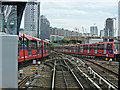
DLR at Poplar station
Looking east from a train at the station.
Image: © Thomas Nugent
Taken: 5 Jun 2015
0.06 miles
7
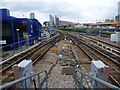
View from the platform at Poplar DLR station
Poplar DLR station was opened on 21 August 1987, originally with just two platforms, being served only by the Stratford-Island Gardens branch of the Docklands Light Railway. As the DLR was expanded eastwards, the station was extensively given two extra platforms. This view looks east from the end of one of the platforms. The flyover carries trains towards Beckton or Woolwich Arsenal whilst trains to and from Stratford pass under the flyover.
Image: © Marathon
Taken: 27 Jul 2011
0.06 miles
8

DLR at Poplar, 1987
This image was taken about a month after the Docklands Light Railway opened to passengers.
At the time, the Isle of Dogs peninsula was being regenerated, it was hoped that the DLR would help to catalyse that regeneration by providing new transport links. Those hopes have been realised, the area has changed beyond recognition in the 25 years since the DLR opened.
The railway opened with a fleet of just 11 trains, each running as a single unit. These original units have since been replaced. By 2012, the fleet had grown to 149 trains, which now run as 2- or 3-units coupled together.
Image: © Malc McDonald
Taken: 29 Sep 1987
0.07 miles
9
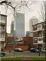
Cottage Street, E14
Taken from a green in the angle between Cottage Street and Smythe Street (immediate left). The older brick buildings across the road are a mortuary and coroner's court. In the background rise the towers of Canary Wharf.
Image: © Derek Harper
Taken: 2 Feb 2011
0.07 miles
10
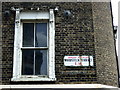
Street names, old and older
Woodstock Road was renamed Woodstock Terrace in 1937 which suggests that the upper sign has been there for 80 years and the lower one a lot longer!
At the junction with Poplar High Street.
Image: © Natasha Ceridwen de Chroustchoff
Taken: 26 Jun 2008
0.07 miles