IMAGES TAKEN NEAR TO
Rectory Square, LONDON, E1 3NG
Introduction
This page details the photographs taken nearby to Rectory Square, E1 3NG by members of the Geograph project.
The Geograph project started in 2005 with the aim of publishing, organising and preserving representative images for every square kilometre of Great Britain, Ireland and the Isle of Man.

There are currently over 7.5m images from over14,400 individuals and you can help contribute to the project by visiting https://www.geograph.org.uk
Image Map (Loading...)


Getting Data...Please wait
Leaflet Map data © OpenStreetMap
Images are licensed for reuse under creativecommons.org/licenses/by-sa/2.0
Notes
- Clicking on the map will re-center to the selected point.
- The higher the marker number, the further away the image location is from the centre of the postcode.
Image Listing (115 Images Found)
Images are licensed for reuse under creativecommons.org/licenses/by-sa/2.0
Image
Details
Distance
1
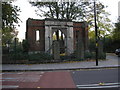
Archway, Stepney
This archway stands on the south side of Stepney Green near the bottom. Perhaps it was the entrance to the Red Coat School, which stood near to here.
Image: © Dr Neil Clifton
Taken: 7 Nov 2007
0.03 miles
2

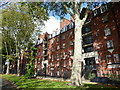
St Dunstan's Rectory, Stepney
Many gables adorn the C19 brick rectory http://www.britishlistedbuildings.co.uk/en-206352-st-dunstan-s-rectory-stepney , situated between White Horse Lane (right) and Rectory Square.
Image: © Derek Harper
Taken: 1 Feb 2011
0.05 miles
3

Pigs at Stepney City Farm
Stepney City Farm is a wonderful community resource in the heart of Stepney and has a real feel of countryside. More about the history of the farm can be seen at https://stepneycityfarm.org/about-the-farm/our-history/ and the web site for the farm with the opening times is at https://stepneycityfarm.org/?utm_source=google&utm_medium=cpc&utm_campaign=150088727&utm_id=150088727&utm_adgroup=7379212367&utm_term=stepney%20city%20farm&adposition&device=c&gclid=EAIaIQobChMI64Tr6qbz9AIVW-ztCh1j4AepEAAYASAAEgKzkvD_BwE
Image: © Marathon
Taken: 14 Dec 2021
0.05 miles
4
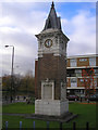
Memorial Clock, Stepney Green
This memorial clock, which stands near the bottom of Stepney Green, is dedicated to the memory of one Stanley Atkinson, who was a barrister and much-valued Councillor and later, Alderman of the borough, but who died in 1910 at the early age of 37.
Image: © Dr Neil Clifton
Taken: 7 Nov 2007
0.06 miles
5
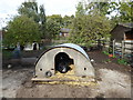
Pig at Stepney City Farm
Stepney City Farm was founded as Stepping Stones Farm in 1979. See http://stepneycityfarm.org/ It also has the Humble Bee Cafe which was reviewed by the Guardian in 2019: https://www.theguardian.com/food/2019/sep/29/the-humble-bee-cafe-stepney-city-farm-london-a-meal-in-a-very-happy-place-restaurant-review?CMP=share_btn_tw
Image: © Marathon
Taken: 9 Oct 2019
0.06 miles
6
White Horse Lane at the junction of Ben Jonson Road
This is the new sixth form block for Stepney Green College, which has just been completed, replacing an earlier smaller building.
Image: © David Howard
Taken: 28 Sep 2019
0.06 miles
7
Stepney Green Court
Stepney Green Court would have originally been one of the many 'improved' dwellings built in the area to replace the slums highlighted at the time of Jack the Ripper. They are now sold as desirable properties - a far cry from their original purpose. This view is from Stepney Green.
See also https://www.geograph.org.uk/photo/6294746
Image: © Marathon
Taken: 9 Oct 2019
0.08 miles
8
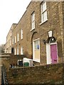
Terraced houses, White Horse Lane
Identical keystone faces are seen in Exeter on late C18 doorways; this is also presumably made of Coade Stone. The house it adorns is listed http://www.britishlistedbuildings.co.uk/en-206351-27-stepney .
Image: © Derek Harper
Taken: 1 Feb 2011
0.08 miles
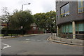
9
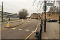
Junction in Stepney
The mini-roundabout is at the junction of Stepney High Street (right) with Ben Jonson Road. On the left is Stepney Green Maths, Science & Computing College
Image: © Derek Harper
Taken: 1 Feb 2011
0.08 miles
10

White Horse Lane
Buildings along the west side of the road, the nearer ones facing the demolition site shown in Image
Image: © Derek Harper
Taken: 1 Feb 2011
0.09 miles