IMAGES TAKEN NEAR TO
Hannibal Road, LONDON, E1 3JD
Introduction
This page details the photographs taken nearby to Hannibal Road, E1 3JD by members of the Geograph project.
The Geograph project started in 2005 with the aim of publishing, organising and preserving representative images for every square kilometre of Great Britain, Ireland and the Isle of Man.

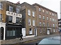
There are currently over 7.5m images from over14,400 individuals and you can help contribute to the project by visiting https://www.geograph.org.uk
Image Map
Images are licensed for reuse under creativecommons.org/licenses/by-sa/2.0
Notes
- Clicking on the map will re-center to the selected point.
- The higher the marker number, the further away the image location is from the centre of the postcode.
Image Listing (163 Images Found)
Images are licensed for reuse under creativecommons.org/licenses/by-sa/2.0
Image
Details
Distance
1
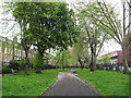
Stepney Green
This sliver of public gardens runs for about 300 metres along Stepney Green.
Image: © Nigel Cox
Taken: 1 May 2008
0.02 miles
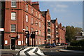
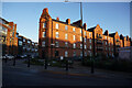
2
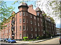
Stepney Green: Dunstan Houses, E1
Like Image on the other side of Stepney Green, Dunstan Houses was built with capital funded by affluent and philanthropic Jewish businessmen to replace older slum housing with modern but low cost accommodation for workers. Dunstan Houses was built by the East End Dwellings Company Limited and was completed in 1899.
Image: © Nigel Cox
Taken: 1 May 2008
0.02 miles
3
Stepney Green: B121 Stepney Green
Like several other locations the name of the area and the name of the street are the same, Stepney Green in this case. However the reason for taking the photograph was to record the very well-maintained Daren Bread advertisement painted on the house front, having seen a similar advertisement for the same bread in Stone in Kent a couple of months previously. See Image
Image: © Nigel Cox
Taken: 1 May 2008
0.02 miles
4

Flats in Hannibal Road
The open stairways give the residents space to hang their washing. When these were built, the balconies would have been quieter, with less traffic.
Image: © David Smith
Taken: 20 Nov 2012
0.02 miles
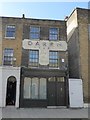
5
Former bakery in Stepney Green
There's no modesty in the claim "Best for health"
Image: © David Smith
Taken: 20 Nov 2012
0.02 miles
6
Ghost sign at Stepney Green
This is just south of Mile End Road. The name derived from the fact that the flour was ground at the Daren Mill on the River Darent at Dartford in Kent.
There are some interesting links connected with Daren Bread:
https://www.london-walking-tours.co.uk/secret-london/daren-bread.htm This one states that:- "However, the mill that produced Daren flour went bankrupt in the 1930's and eventually the Daren Brand was merged into the Hovis brand and phased out. But its name has lived on in the ghost signs that can still be seen on walls all over the country where, just like the one that can be admired on a wall on Stepney Green, we can reminded of the good old days when manufacturers could make all manner of claims for their products without fear of official censure."
See also https://www.ghostsigns.co.uk/2017/01/when-daren-became-hovis-a-bizarre-ghostsigns-restoration/
Image: © Marathon
Taken: 9 Oct 2019
0.03 miles
7
Cressy Place, East London
This fine block of flats was built in 1894. This was a time when Londoners were not used to living in flats at all, but the high standard of accommodation has ensured they have passed the test of time, (as well as surviving Hitler's war).
Image: © Dr Neil Clifton
Taken: 23 Oct 2007
0.03 miles
8
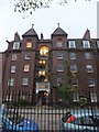
Dunstan House flats
The architect of these flats seems to have been thinking of building a castle in East London, with the twin towers sandwiching the open stairway.
Image: © David Smith
Taken: 20 Nov 2012
0.04 miles
9
Turf Zone "CressyPlace"
Cressy Houses on Cressy Place, Stepney, London.
Image: © Ian S
Taken: 26 Dec 2022
0.04 miles