IMAGES TAKEN NEAR TO
White Horse Lane, LONDON, E1 3FX
Introduction
This page details the photographs taken nearby to White Horse Lane, E1 3FX by members of the Geograph project.
The Geograph project started in 2005 with the aim of publishing, organising and preserving representative images for every square kilometre of Great Britain, Ireland and the Isle of Man.

There are currently over 7.5m images from over14,400 individuals and you can help contribute to the project by visiting https://www.geograph.org.uk
Image Map
Images are licensed for reuse under creativecommons.org/licenses/by-sa/2.0
Notes
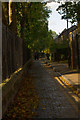
- Clicking on the map will re-center to the selected point.
- The higher the marker number, the further away the image location is from the centre of the postcode.
Image Listing (157 Images Found)
Images are licensed for reuse under creativecommons.org/licenses/by-sa/2.0
Image
Details
Distance
1

White Horse Lane, Stepney
Looking towards Mile End Road with Caspian house on the right.
Image: © Stephen McKay
Taken: 4 Sep 2009
0.02 miles
2

White Horse Lane
Buildings along the west side of the road, the nearer ones facing the demolition site shown in Image
Image: © Derek Harper
Taken: 1 Feb 2011
0.03 miles
3
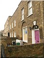
Terraced houses, White Horse Lane
Identical keystone faces are seen in Exeter on late C18 doorways; this is also presumably made of Coade Stone. The house it adorns is listed http://www.britishlistedbuildings.co.uk/en-206351-27-stepney .
Image: © Derek Harper
Taken: 1 Feb 2011
0.03 miles
4
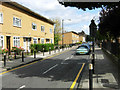
Shandy Street, Stepney
Post-war development, seen from the junction with White Horse Lane, in an area whose original housing was devastated by the blitz.
Image: © Stephen McKay
Taken: 4 Sep 2009
0.04 miles
5

Demolition on Shandy Street
A glimpse through a fence on White Horse Lane of a large demolition site. Caspian House, Darien House, Riga House and Flores House are all gone; the machine is at work on Bengal House, which adjoins Duckett Street on the other side. A building has so far survived in between.
Image: © Derek Harper
Taken: 1 Feb 2011
0.04 miles
6

St Dunstan's Rectory, Stepney
Many gables adorn the C19 brick rectory http://www.britishlistedbuildings.co.uk/en-206352-st-dunstan-s-rectory-stepney , situated between White Horse Lane (right) and Rectory Square.
Image: © Derek Harper
Taken: 1 Feb 2011
0.08 miles
9
Cobbled path, Stepney Green Gardens
Stepney Green Gardens is fully described at this http://www.londongardensonline.org.uk/gardens-online-record.asp?ID=THM053.
Image: © Jim Osley
Taken: 24 Oct 2013
0.12 miles
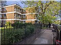
10
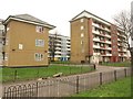
Flats, Mile End
On the right is Magellan House, on the left, Pacific House. Between the two can be seen Bantry House.
Image: © Derek Harper
Taken: 1 Feb 2011
0.12 miles