IMAGES TAKEN NEAR TO
Tunmarsh Lane, LONDON, E13 9NG
Introduction
This page details the photographs taken nearby to Tunmarsh Lane, E13 9NG by members of the Geograph project.
The Geograph project started in 2005 with the aim of publishing, organising and preserving representative images for every square kilometre of Great Britain, Ireland and the Isle of Man.

There are currently over 7.5m images from over14,400 individuals and you can help contribute to the project by visiting https://www.geograph.org.uk
Image Map
Images are licensed for reuse under creativecommons.org/licenses/by-sa/2.0
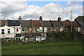
Notes
- Clicking on the map will re-center to the selected point.
- The higher the marker number, the further away the image location is from the centre of the postcode.
Image Listing (59 Images Found)
Images are licensed for reuse under creativecommons.org/licenses/by-sa/2.0
Image
Details
Distance
2
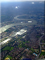
Greenwich from the air
Looking over East Ham towards Greenwich and the Isle of Dogs. Viewed from a Heathrow bound flight from Glasgow.
Image: © Thomas Nugent
Taken: 29 Aug 2011
0.06 miles
3
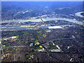
London City Airport from the air
Looking over East Ham and Beckton towards the airport at Albert Dock. The Thames Barrier can be seen beyond the airport. Viewed from a Heathrow bound flight from Glasgow.
Image: © Thomas Nugent
Taken: 29 Aug 2011
0.06 miles
4
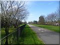
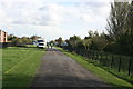
On the Greenway above the Northern Outfall Sewer
By the 1850s the River Thames in Central London was a vast open sewer and “The Great Stink” of 1855 brought matters to a head. The smell was so strong that curtains soaked in calcium chloride had to be hung over the windows of the Houses of Parliament facing the river. The Government finally acknowledged the problem and established the Metropolitan Board of Works. Their first task was the provision of a proper sewerage and drainage system. The Northern and Southern Outfall Sewers were constructed between 1860 and 1865, the former carrying sewage from northern London to the Northern Outfall Works at Beckton. The Greenway has been opened up on top as a footway and cycle track and runs all the way from Victoria Park to Beckton. The Capital Ring follows most of it.
Newham University Hospital is alongside the Greenway to the left here.
Image: © Marathon
Taken: 10 Mar 2015
0.06 miles
7
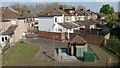
Looking down on houses in Humberstone Road
Seen from the Greenway, which is built over the Northern Outfall Sewer. Here there is a small triangular yard with some related infrastructure.
Image: © David Martin
Taken: 7 Apr 2017
0.07 miles
8
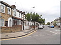
New City Road, Plaistow
These roads are typical of the entire area from West Hame to Barking and were partly built to house the industrial workers on and around the river when the docks were still active.
Image: © David Howard
Taken: 27 Apr 2014
0.07 miles
9
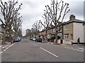
New City Road at the junction of Boundary Road
Image: © David Howard
Taken: 27 Apr 2014
0.07 miles
10
Boundary Road at the junction of New City Road
Image: © David Howard
Taken: 27 Apr 2014
0.08 miles