IMAGES TAKEN NEAR TO
Fawn Road, LONDON, E13 9BL
Introduction
This page details the photographs taken nearby to Fawn Road, E13 9BL by members of the Geograph project.
The Geograph project started in 2005 with the aim of publishing, organising and preserving representative images for every square kilometre of Great Britain, Ireland and the Isle of Man.

There are currently over 7.5m images from over14,400 individuals and you can help contribute to the project by visiting https://www.geograph.org.uk
Image Map (Loading...)


Getting Data...Please wait
Leaflet Map data © OpenStreetMap
Images are licensed for reuse under creativecommons.org/licenses/by-sa/2.0
Notes
- Clicking on the map will re-center to the selected point.
- The higher the marker number, the further away the image location is from the centre of the postcode.
Image Listing (111 Images Found)
Images are licensed for reuse under creativecommons.org/licenses/by-sa/2.0
Image
Details
Distance
1
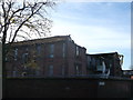
Plaistow Hospital under demolition
This hospital on the corner of Southern Road and Credon Road. Closed in 2006.
The land has been sold to developers. Some parts of the hospital have been demolished already.
Image: © David Anstiss
Taken: 16 Dec 2012
0.08 miles

3
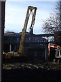
Wrecking machines, Plaistow Hospital
This hospital on Southern Road. Closed in 2006.
The land has been sold to developers. Some parts of the hospital have been demolished already.
Image: © David Anstiss
Taken: 16 Dec 2012
0.11 miles
5
Power Plant, Plasitow Hospital
As seen from the junction of Nile Road and Credon Road.
Image: © David Anstiss
Taken: 16 Dec 2012
0.11 miles
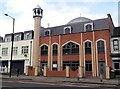
7

Our Lady of Compassion Catholic Church, Green Street
This church is on the corner of Green Street and Castle Street. The West Ham football ground is just visible in the background.
Image: © Danny P Robinson
Taken: 20 May 2007
0.12 miles
8
Store Deliveries, Plaistow Hospital
Disused hospital building on Nile Road.
Image: © David Anstiss
Taken: 16 Dec 2012
0.13 miles
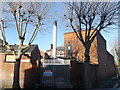
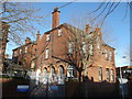
9
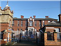
Entrance to Plaistow Hospital
The main Sydenham Building, as seen from Samson Street.
Image: © David Anstiss
Taken: 16 Dec 2012
0.13 miles
10

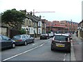
Barking Road at the junction of Green Street
West Ham football ground is behind the bus
Image: © David Howard
Taken: 27 Apr 2014
0.14 miles