IMAGES TAKEN NEAR TO
Palmer Road, LONDON, E13 8NT
Introduction
This page details the photographs taken nearby to Palmer Road, E13 8NT by members of the Geograph project.
The Geograph project started in 2005 with the aim of publishing, organising and preserving representative images for every square kilometre of Great Britain, Ireland and the Isle of Man.

There are currently over 7.5m images from over14,400 individuals and you can help contribute to the project by visiting https://www.geograph.org.uk
Image Map
Images are licensed for reuse under creativecommons.org/licenses/by-sa/2.0
Notes
- Clicking on the map will re-center to the selected point.
- The higher the marker number, the further away the image location is from the centre of the postcode.
Image Listing (13 Images Found)
Images are licensed for reuse under creativecommons.org/licenses/by-sa/2.0
Image
Details
Distance
1
Houses on Jenkins Road, Newham
A distinctive style of housing, probably early 20th century.
Image: © Stephen Craven
Taken: 15 May 2010
0.11 miles
2
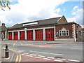
Newham Fire Station
The fire station is on Prince Regent Lane.
Image: © Stephen Craven
Taken: 15 May 2010
0.13 miles
3
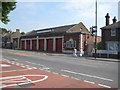
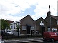
Plaistow Fire Station
Plaistow Fire Station on the A112 Prince Regent Lane is one of nine old fire stations across London that were originally planned to be revamped in 2009 as part of a £57.4 million Private Finance Initiative. However the plans were put on hold when the Coalition Government came to power in 2010. The Department for Communities and Local Government has now announced the money will be made available and work is expected to start in late 2012. Plaistow’s fire engine resources will be temporarily transferred during the construction works to Stratford and East Ham Fire Stations.
Image: © Nigel Cox
Taken: 3 Aug 2011
0.13 miles
4
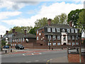
Duke of Cumberland Public House, Plaistow
On the junction of Elkington Road (on the left) and Cumberland Road.
Image: © David Anstiss
Taken: 26 Aug 2012
0.15 miles
5
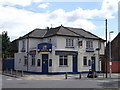
Assembles of God (Back to God) Church, Plaistow
Modern church on the junction of Cumberland Road and Holborn Road (on the left).
Image: © David Anstiss
Taken: 26 Aug 2012
0.16 miles
6
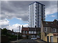
Lincoln Road, Plaistow
A small road in the district.
In the background is Stubbs Point (block of housing).
Image: © David Anstiss
Taken: 26 Aug 2012
0.18 miles
7
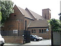
London Ghana Seventh Day Adventist Church, Plaistow
Church on Chadwin Road.
Image: © David Anstiss
Taken: 26 Aug 2012
0.18 miles
9
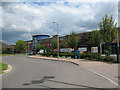
The Cumberland School, Newham
The school on Oban Close is a specialist sports college. According to its online prospectus it was opened in 2005 on the site of the former Woodside Community School.
Image: © Stephen Craven
Taken: 15 May 2010
0.23 miles
10
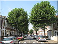
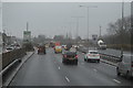
Plaistow: Wigston Road, E13
London Plane trees form an avenue along this road of Victorian houses.
Image: © Nigel Cox
Taken: 3 Aug 2011
0.23 miles