IMAGES TAKEN NEAR TO
Croydon Road, LONDON, E13 8ER
Introduction
This page details the photographs taken nearby to Croydon Road, E13 8ER by members of the Geograph project.
The Geograph project started in 2005 with the aim of publishing, organising and preserving representative images for every square kilometre of Great Britain, Ireland and the Isle of Man.

There are currently over 7.5m images from over14,400 individuals and you can help contribute to the project by visiting https://www.geograph.org.uk
Image Map
Images are licensed for reuse under creativecommons.org/licenses/by-sa/2.0
Notes
- Clicking on the map will re-center to the selected point.
- The higher the marker number, the further away the image location is from the centre of the postcode.
Image Listing (34 Images Found)
Images are licensed for reuse under creativecommons.org/licenses/by-sa/2.0
Image
Details
Distance
1
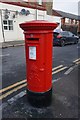
Georgian post box
On Hermit Road at Blanche Street, Canning Town.
Image: © Ian S
Taken: 28 Jan 2020
0.07 miles
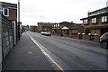
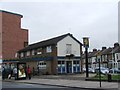
3
S & R Off Licence on Hermit Road, Canning Town
Image: © Ian S
Taken: 28 Jan 2020
0.08 miles
6
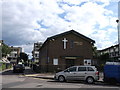
Canning Town Evangelical Church
On Cliff Walk.
Image: © David Anstiss
Taken: 26 Aug 2012
0.11 miles
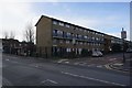
9
The Hub, Star Lane
Community Centre, cafe and social services resource.
Image: © David Anstiss
Taken: 26 Aug 2012
0.14 miles