IMAGES TAKEN NEAR TO
Queens Road West, LONDON, E13 0PE
Introduction
This page details the photographs taken nearby to Queens Road West, E13 0PE by members of the Geograph project.
The Geograph project started in 2005 with the aim of publishing, organising and preserving representative images for every square kilometre of Great Britain, Ireland and the Isle of Man.

There are currently over 7.5m images from over14,400 individuals and you can help contribute to the project by visiting https://www.geograph.org.uk
Image Map (Loading...)


Getting Data...Please wait
Leaflet Map data © OpenStreetMap
Images are licensed for reuse under creativecommons.org/licenses/by-sa/2.0
Notes
- Clicking on the map will re-center to the selected point.
- The higher the marker number, the further away the image location is from the centre of the postcode.
Image Listing (61 Images Found)
Images are licensed for reuse under creativecommons.org/licenses/by-sa/2.0
Image
Details
Distance
1
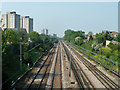
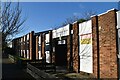
Railway between Upton Park and Plaistow
Looking west towards Plaistow from the Carter Road bridge.
Image: © Robin Webster
Taken: 24 Apr 2011
0.03 miles
7
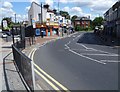
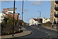
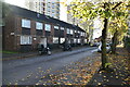
Shops in Terrace Road, Plaistow
The shops in Terrace Road are seen here from Pelly Road which continues on the left.
Image: © Marathon
Taken: 21 Aug 2014
0.09 miles
8
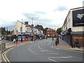
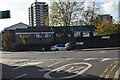
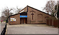
Terrace Road, West Ham
Terrace Road in West Ham, in east London.
Image: © Malc McDonald
Taken: 3 Sep 2017
0.11 miles