IMAGES TAKEN NEAR TO
East Avenue, LONDON, E12 6SQ
Introduction
This page details the photographs taken nearby to East Avenue, E12 6SQ by members of the Geograph project.
The Geograph project started in 2005 with the aim of publishing, organising and preserving representative images for every square kilometre of Great Britain, Ireland and the Isle of Man.

There are currently over 7.5m images from over14,400 individuals and you can help contribute to the project by visiting https://www.geograph.org.uk
Image Map
Images are licensed for reuse under creativecommons.org/licenses/by-sa/2.0
Notes
- Clicking on the map will re-center to the selected point.
- The higher the marker number, the further away the image location is from the centre of the postcode.
Image Listing (79 Images Found)
Images are licensed for reuse under creativecommons.org/licenses/by-sa/2.0
Image
Details
Distance
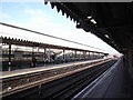
2
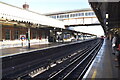
Eastbound platform, East Ham station
Looking west, with the site of the former bay platform for St. Pancras/Kentish Town services on the right.
Image: © Robin Webster
Taken: 24 Apr 2011
0.06 miles
3
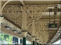
LTSR brackets, East Ham station
A wonderful array of brackets on this station built by the London, Tilbury and Southend Railway during their period of expansion. Several stations on this stretch of line are similarly equipped, but earlier and later (post-LTSR) stations are less ornate. Several station seats also have LTSR cast into their uprights - these are more widely spread.
Image: © Robin Webster
Taken: 24 Apr 2011
0.06 miles
4
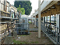
Site of former bay platform, East Ham station
The platform was used for terminating services from St. Pancras and, mostly, Kentish Town. This service also used Barking as a terminus, the split between the two varying over the years. The service to East Ham was withdrawn in 1958 after a period of exclusive use whilst the layout west of Barking was drastically remodelled in preparation for electrification. The west side of the Little Ilford triangle which was used by the service was then removed.
Image: © Robin Webster
Taken: 24 Apr 2011
0.07 miles
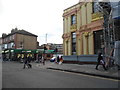
5
Junction of High Street North and East Avenue
Image: © David Martin
Taken: 11 Oct 2016
0.07 miles
6
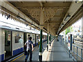
Platforms East Ham Underground Station
Westbound platform looking east
Image: © Robin Sones
Taken: 27 Feb 2013
0.07 miles
7
High Street North, East Ham
At the junction of Plashet Grove
Image: © David Howard
Taken: 12 Nov 2017
0.07 miles
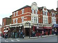
9
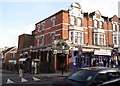
The Overdraft Tavern, High Street North E6
At the junction with Sibley Grove (E12)
Image: © Robin Sones
Taken: 27 Feb 2013
0.08 miles
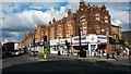
10
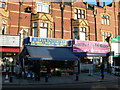
Shops on High Street North, E12
Near the junction with East Avenue (a short way to the right). The door on the far right of the picture leads to a Masjid above the local Somerfield.
Image: © Danny P Robinson
Taken: 12 Feb 2008
0.08 miles