IMAGES TAKEN NEAR TO
Coleridge Avenue, LONDON, E12 6RQ
Introduction
This page details the photographs taken nearby to Coleridge Avenue, E12 6RQ by members of the Geograph project.
The Geograph project started in 2005 with the aim of publishing, organising and preserving representative images for every square kilometre of Great Britain, Ireland and the Isle of Man.

There are currently over 7.5m images from over14,400 individuals and you can help contribute to the project by visiting https://www.geograph.org.uk
Image Map
Images are licensed for reuse under creativecommons.org/licenses/by-sa/2.0
Notes
- Clicking on the map will re-center to the selected point.
- The higher the marker number, the further away the image location is from the centre of the postcode.
Image Listing (41 Images Found)
Images are licensed for reuse under creativecommons.org/licenses/by-sa/2.0
Image
Details
Distance
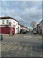
1
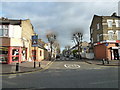
From the City's Cemetery to the Greenway (55)
Looking into Coleridge Road.
Image: © Basher Eyre
Taken: 7 Jan 2012
0.07 miles
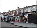
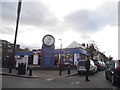
2
From the City's Cemetery to the Greenway (52)
The Fish Corner
Image: © Basher Eyre
Taken: 7 Jan 2012
0.08 miles
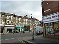
3
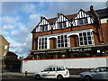
From the City's Cemetery to the Greenway (57)
The Ruskin Arms- where an embryonic Iron Maiden http://en.wikipedia.org/wiki/Iron_Maiden cut their teeth: a heavy metal Blue plaque http://en.wikipedia.org/wiki/Blue_plaque is called for, methinks!
Image: © Basher Eyre
Taken: 7 Jan 2012
0.08 miles
4
From the City's Cemetery to the Greenway (53)
Looking into Stanley Road
Image: © Basher Eyre
Taken: 7 Jan 2012
0.09 miles
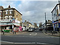
5
From the City's Cemetery to the Greenway (56)
Looking from Strone Road.
Image: © Basher Eyre
Taken: 7 Jan 2012
0.09 miles
7
From the City's Cemetery to the Greenway (58)
Looking into Goldsmith Avenue.
Image: © Basher Eyre
Taken: 7 Jan 2012
0.10 miles
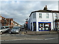
8
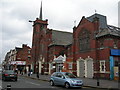
Shalom Centre, 395 High Street North, E12 6PG
This was once a church, it is now a Community Resource Centre. It offers community meeting facilities and help with finding employment. The blue sign on the wall is for a Kwik-Fit next door.
Image: © Danny P Robinson
Taken: 28 May 2007
0.11 miles
9
From the City's Cemetery to the Greenway (54)
Looking along Monega Road
Image: © Basher Eyre
Taken: 7 Jan 2012
0.11 miles