IMAGES TAKEN NEAR TO
Grantham Road, LONDON, E12 5RW
Introduction
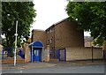
This page details the photographs taken nearby to Grantham Road, E12 5RW by members of the Geograph project.
The Geograph project started in 2005 with the aim of publishing, organising and preserving representative images for every square kilometre of Great Britain, Ireland and the Isle of Man.

There are currently over 7.5m images from over14,400 individuals and you can help contribute to the project by visiting https://www.geograph.org.uk
Image Map
Images are licensed for reuse under creativecommons.org/licenses/by-sa/2.0
Notes
- Clicking on the map will re-center to the selected point.
- The higher the marker number, the further away the image location is from the centre of the postcode.
Image Listing (58 Images Found)
Images are licensed for reuse under creativecommons.org/licenses/by-sa/2.0
Image
Details
Distance
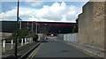
1
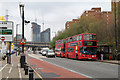
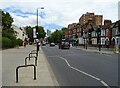
Romford Road
The A118 looking towards Ilford and the A406 flyover. The twin towers are Pioneer Point, currently under construction. A pair of buses collect passengers from beside the Grantham Road Estate in Manor Park
Image: © Martin Addison
Taken: 17 Nov 2010
0.03 miles
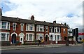
3
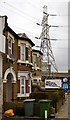
Life in the Shadow
Two surviving houses, probably once part of a longer terrace, stand in the shadow of an electricity pylon on Romford Road. They are surrounded by car dealers and a tyre supplier. I wonder how many more years they will survive before being redeveloped?
Image: © Martin Addison
Taken: 17 Nov 2010
0.08 miles
4
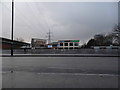
View of the Tunnelling and Underground Construction Academy from Romford Road
The Tunnelling and Underground Construction Academy is the place to come if you are interested in being a tunnelling engineer for the railway construction industry. It is built on the site of a former train driver training facility. Looking north-northwest.
Image: © Robert Lamb
Taken: 26 Feb 2014
0.09 miles
5
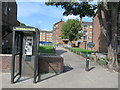
Path to Aldersbrook Lane, near Ilford
A short path leading into a housing estate near Ilford in east London.
The circular sign to the right of the path indicates that it leads to the Roding Valley Way path. The small blue circular sign in the foreground shows that this path is shared by pedestrians and cyclists.
Image: © Malc McDonald
Taken: 10 Sep 2020
0.10 miles