IMAGES TAKEN NEAR TO
Sheringham Avenue, LONDON, E12 5PB
Introduction
This page details the photographs taken nearby to Sheringham Avenue, E12 5PB by members of the Geograph project.
The Geograph project started in 2005 with the aim of publishing, organising and preserving representative images for every square kilometre of Great Britain, Ireland and the Isle of Man.

There are currently over 7.5m images from over14,400 individuals and you can help contribute to the project by visiting https://www.geograph.org.uk
Image Map
Images are licensed for reuse under creativecommons.org/licenses/by-sa/2.0
Notes
- Clicking on the map will re-center to the selected point.
- The higher the marker number, the further away the image location is from the centre of the postcode.
Image Listing (58 Images Found)
Images are licensed for reuse under creativecommons.org/licenses/by-sa/2.0
Image
Details
Distance
1
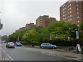
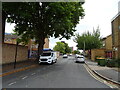
Romford Road near Dersingham Avenue, E12
I am standing in the south eastern corner of TQ4286, but apart from the first half of the nearest one, the tower blocks are all in TQ4386. To the far left of the picture, in the distance, is the A406 flyover and the office blocks near Ilford Centre.
Image: © Danny P Robinson
Taken: 13 May 2007
0.08 miles
4
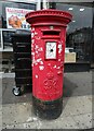
George VI postbox on Romford Road (A118), London
Postbox No. E12 7.
Image: © JThomas
Taken: 22 Aug 2022
0.11 miles
6
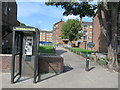
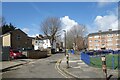
Path to Aldersbrook Lane, near Ilford
A short path leading into a housing estate near Ilford in east London.
The circular sign to the right of the path indicates that it leads to the Roding Valley Way path. The small blue circular sign in the foreground shows that this path is shared by pedestrians and cyclists.
Image: © Malc McDonald
Taken: 10 Sep 2020
0.11 miles
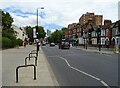
8
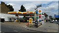
Service station on Romford Road (A118), London
Petrol 169.9p.
Diesel 185.9p.
Image: © JThomas
Taken: 22 Aug 2022
0.12 miles
9
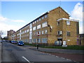
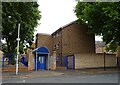
Manor Park: Dersingham Avenue, E12
Flats (or possibly maisonettes) on the east side of Dersingham Avenue, north of its junction with Jack Cornwell Street.
(Jack Cornwell was a 16-year-old boy from Manor Park who was awarded a posthumous Victoria Cross for his actions in staying at his post, although fatally wounded, during the Battle of Jutland in 1916. His grave is here Image)
Image: © Nigel Cox
Taken: 7 Mar 2007
0.13 miles
10
Along the Roding Valley Way 3
The Roding Valley Way follows the course of the river to a varying degree for 10 and a bit kilometres between Woodford and Ilford. The off road path starts between the two housing blocks on the left.
This is Aldersbrook Lane, a residential no through road, which gives access to the path from the main road.
Image: © Des Blenkinsopp
Taken: 2 Apr 2024
0.14 miles