IMAGES TAKEN NEAR TO
Grantham Road, LONDON, E12 5NA
Introduction
This page details the photographs taken nearby to Grantham Road, E12 5NA by members of the Geograph project.
The Geograph project started in 2005 with the aim of publishing, organising and preserving representative images for every square kilometre of Great Britain, Ireland and the Isle of Man.

There are currently over 7.5m images from over14,400 individuals and you can help contribute to the project by visiting https://www.geograph.org.uk
Image Map
Images are licensed for reuse under creativecommons.org/licenses/by-sa/2.0
Notes
- Clicking on the map will re-center to the selected point.
- The higher the marker number, the further away the image location is from the centre of the postcode.
Image Listing (27 Images Found)
Images are licensed for reuse under creativecommons.org/licenses/by-sa/2.0
Image
Details
Distance
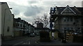
1
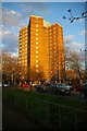
Alfred Pryor House
This tower block is in at the junction of Jack Cornwall Rd and Grantham Rd Ilford.
Image: © Glyn Baker
Taken: 14 Apr 2006
0.03 miles
2
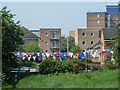
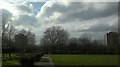
Bunting on Banks Way
Possibly football related?
Image: © Robin Webster
Taken: 24 Apr 2011
0.04 miles
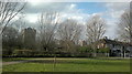
3
View of John Cornwell VC House from the dog exercise area in the park on Lowbrook Road, Ilford
Looking north-northwest. The River Roding (which has been on flood alert recently, posing great risk to nearby houses which back onto the river) flows in a deep cutting behind the railings and greenery in the foreground, whilst the A406 is marked out by the lamp posts.
Image: © Robert Lamb
Taken: 24 Feb 2014
0.08 miles
4
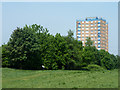
View of Alfred Prior House, Grantham Road from the park on Lowbrook Road, Ilford
In the area between Kenneth Avenue and Lowbrook and Cecil Roads in Ilford is a small, unnamed park. One of the views to be had from the park is this one of Alfred Prior House, which is actually in the London Borough of Newham. Looking north-northwest.
Image: © Robert Lamb
Taken: 24 Feb 2014
0.08 miles
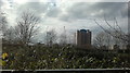
5
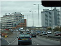
Tower Blocks in Ilford
As one travels down the westbound A406 from Beckton, Ilford is clearly marked out by these two tower blocks. On the left, we have the BT tower, which is shown in my image from Hainault Street railway bridge, and on the right is what I believe is just an office block. View taken from the westbound A406 at the Ilford turn-off, looking north-east.
Image: © Robert Lamb
Taken: 25 Oct 2008
0.09 miles
6
View of Alfred Prior and John Cornwell VC House from the park on Lowbrook Road, Ilford
In the area between Kenneth Avenue and Lowbrook and Cecil Roads in Ilford is a small, unnamed park. One of the views to be had from the park is this one of Alfred Prior House and John Cornwell VC House, which are actually in the London Borough of Newham. Looking north-northwest.
Image: © Robert Lamb
Taken: 24 Feb 2014
0.11 miles
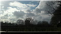
7
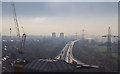
A406 North Circular Road
A view from Mill House on Ilford Hill looking towards Barking on a misty November morning in the Roding Valley. The River Roding is in the trees to the left of the dual carriageway.
Image: © Martin Addison
Taken: 15 Nov 2010
0.11 miles
8
John Cornwell V.C. House, E12
Viewed from open space by the River Roding.
Image: © Robin Webster
Taken: 24 Apr 2011
0.14 miles
9
View of Alfred Prior House from Riverdene Road
Looking west along Falaize Avenue.
Image: © Robert Lamb
Taken: 24 Feb 2014
0.14 miles
10
View of John Cornwell VC, Roding, Twelve Acre, Blakesley, Arthur Walls, Willis, and Charlbury Houses through the trees
In the area between Kenneth Avenue and Lowbrook and Cecil Roads in Ilford is a small, unnamed park. One of the views to be had from the park is this one through the trees of John Cornwell VC, Roding, Twelve Acre, Blakesley, Arthur Walls, Willis, and Charlbury Houses, all on Grantham Road, which is actually in the London Borough of Newham. The A406 can also just be seen, marked out by the grey and white lighting standards. Looking north-northwest.
Image: © Robert Lamb
Taken: 24 Feb 2014
0.14 miles