IMAGES TAKEN NEAR TO
Sunderland Way, LONDON, E12 5HR
Introduction
This page details the photographs taken nearby to Sunderland Way, E12 5HR by members of the Geograph project.
The Geograph project started in 2005 with the aim of publishing, organising and preserving representative images for every square kilometre of Great Britain, Ireland and the Isle of Man.

There are currently over 7.5m images from over14,400 individuals and you can help contribute to the project by visiting https://www.geograph.org.uk
Image Map
Images are licensed for reuse under creativecommons.org/licenses/by-sa/2.0
Notes
- Clicking on the map will re-center to the selected point.
- The higher the marker number, the further away the image location is from the centre of the postcode.
Image Listing (118 Images Found)
Images are licensed for reuse under creativecommons.org/licenses/by-sa/2.0
Image
Details
Distance
1
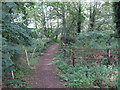
Horse Riding Track
Track near riding school Image] at the edge of Wanstead Park
Image: © Roger Jones
Taken: 28 Jul 2011
0.07 miles
2

Block of Flats Aldersbrook
This block of flats on Empress Avenue is built in the shape of a rectangle with the lowest level being occupied by car parking spaces. The blocks of flats on either side are joined by walkways at the ends of the first and second floor levels resulting in an enclosed central space in which this photo was taken. The trees in the background are in the City of London cemetery.
Image: © Nigel Mykura
Taken: 4 Aug 2012
0.08 miles
3
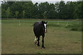
View of a horse in the Aldersbrook Riding School paddock in Wanstead Park
Looking south-southeast.
Image: © Robert Lamb
Taken: 6 May 2017
0.11 miles
4
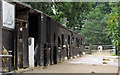
Riding School Stables
At the edge of Wanstead Park
Image: © Roger Jones
Taken: 28 Jul 2011
0.12 miles
5
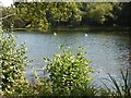
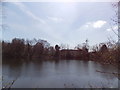
Perch Pond, Wanstead Park
The park itself was not enclosed until 1545. In 1541, the previous owner Sir Giles Heron was beheaded at Tyburn for refusing to acknowledge Henry VIII as head of the Church of England. Wanstead Park began to take on its present form under Sir Joshua Child whose wealth was acquired through the East India trade. It was Sir Joshua's son, Sir Richard Child, who in 1715 commissioned Colin Campbell to design a palatial new mansion here which he intended to be to East London what Hampton Court was to the west. The final mansion though was a good deal more modest. The park was described at that time as one of the finest examples of the English Landscape Movement of the 18th century.
The property's demise came soon after Catherine Tylney-Long, who had just inherited the estate, married the nephew of the Duke of Wellington. Within ten years she went from being the richest heiress in England outside the Royal family to being with her husband a quarter of a million pound in debt. The house contents, including furniture and art collection, had to be sold, and the mansion was demolished and sold for building stone in 1824. However, two of the original garden houses, dating from the mid-18th century when Wanstead House was still a private estate, survived.
Following the Epping Forest Act of 1878, the mansionless park was acquired by the Corporation of the City of London. Wanstead Park was then formally opened to the public on 1st August 1882.
Extending along the southern and eastern boundaries is a one-and-a-half-mile long chain of lakes - Shoulder of Mutton Pond, Heronry Pond, Perch Pond and Ornamental Water. This is Perch Pond.
For more information see https://en.wikipedia.org/wiki/Wanstead_Park and http://www.londongardenstrust.org/features/wanstead.htm
Image: © Marathon
Taken: 17 Aug 2016
0.12 miles
6
View across Perch Pond
Looking south. The rear of a house on Northumberland Avenue can just be glimpsed through the trees.
Image: © Robert Lamb
Taken: 21 Apr 2013
0.12 miles
8

View of Pioneer Point, Ilford from Wanstead Park
Looking south-southeast.
Image: © Robert Lamb
Taken: 21 Apr 2013
0.13 miles
9
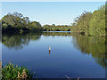
Perch Pond, Wanstead Park
No perch were noted, the only fish seen was, quite remarkably, a pike, lurking in the shallow water close to the bank, and apparently unfazed by passing humans. The depth marker is a puzzle, calibrated in units smaller than feet and much larger than centimetres - possibly tenths of a metre.
Image: © Robin Webster
Taken: 9 Apr 2011
0.13 miles
10
Celebrating the City of London Cemetery (158)
Image: © Basher Eyre
Taken: 3 Sep 2016
0.13 miles