IMAGES TAKEN NEAR TO
Pinchin Street, LONDON, E1 1SA
Introduction
This page details the photographs taken nearby to Pinchin Street, E1 1SA by members of the Geograph project.
The Geograph project started in 2005 with the aim of publishing, organising and preserving representative images for every square kilometre of Great Britain, Ireland and the Isle of Man.

There are currently over 7.5m images from over14,400 individuals and you can help contribute to the project by visiting https://www.geograph.org.uk
Image Map
Images are licensed for reuse under creativecommons.org/licenses/by-sa/2.0
Notes
- Clicking on the map will re-center to the selected point.
- The higher the marker number, the further away the image location is from the centre of the postcode.
Image Listing (186 Images Found)
Images are licensed for reuse under creativecommons.org/licenses/by-sa/2.0
Image
Details
Distance
1
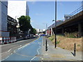
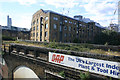
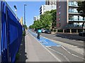
Cycle Superhighway 3 near Shadwell
Two "Cycle Superhighways" (numbered 3 and 7) were introduced by the Mayor of London in 2010, with more planned. They are intended as highly visible, well-signposted "corridor" routes into Central London, identifiable by their bright blue tarmac.
Here in the East End, Cycle Superhighway 3 uses a shared pavement to provide a two-way cycle lane. The adjacent road is one way only.
On the viaduct above, a Docklands Light Railway train is passing.
Image: © Malc McDonald
Taken: 3 Jun 2011
0.03 miles
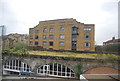
5
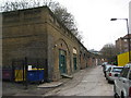
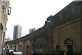
Pinchin Street, E1
The shape of this street is entirely dictated by the railway, long since gone, however the units under the arches are taken with small businesses. This was a goods railway leading north for about 400 yards from the main Fenchurch Street to Southend line, terminating at a very large goods depot bordered by Commercial Road, Gower's Walk and Leman Street.
Image: © Paul E Smith
Taken: 15 Feb 2010
0.05 miles
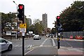
6
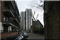
View of Hatton House from Wellclose Square #2
Looking east.
Image: © Robert Lamb
Taken: 20 Mar 2016
0.08 miles
7
Former branch line to Commercial Road goods station, London E1
This stretch of now trackless viaduct once carried a branch line from the main line to Fenchurch Street into Commercial Road goods depot. This stood just to the south of Commercial Road near its junction with Alie Street. The line was opened in 1886 by the London Tilbury & Southend Railway to carry goods traffic from the Tilbury Docks and survived until 1967. Today it can only be traced as far as Back Church Street which is marked by the row of low rise flats on the centre left of the picture. Taken from a C2C train bound for Shoeburyness.
Image: © David Kemp
Taken: 13 Aug 2016
0.08 miles
8
View of Hatton House from Wellclose Square
Looking east.
Image: © Robert Lamb
Taken: 20 Mar 2016
0.09 miles
10
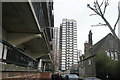
View of old railway arches on Pinchin Street
Pinchin Street was the site where a woman's torso was discovered at 5:15am on Tuesday 10th September 1889 under one of these railway arches. No other body parts were found, despite a search of the area, and neither the victim nor culprit were identified. The age of the victim was estimated at 30-40 years. Looking southeast.
Image: © Robert Lamb
Taken: 20 Mar 2016
0.09 miles