IMAGES TAKEN NEAR TO
Commercial Road, LONDON, E1 1NY
Introduction
This page details the photographs taken nearby to Commercial Road, E1 1NY by members of the Geograph project.
The Geograph project started in 2005 with the aim of publishing, organising and preserving representative images for every square kilometre of Great Britain, Ireland and the Isle of Man.

There are currently over 7.5m images from over14,400 individuals and you can help contribute to the project by visiting https://www.geograph.org.uk
Image Map
Images are licensed for reuse under creativecommons.org/licenses/by-sa/2.0
Notes
- Clicking on the map will re-center to the selected point.
- The higher the marker number, the further away the image location is from the centre of the postcode.
Image Listing (446 Images Found)
Images are licensed for reuse under creativecommons.org/licenses/by-sa/2.0
Image
Details
Distance
1
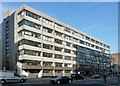
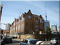
41-71 Commercial Road
By C.H. Elsom & Partners, 1964-66, and altered for the London School of Economics in 1967. The frame is clad in white vitreous tiles.
Now home to London Metropolitan University's Sir John Cass Faculty of Art, Architecture and Design.
Image: © Stephen Richards
Taken: 12 Mar 2012
0.02 miles
2
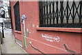
View of mushroom and Elizabeth Stride Street wall art at the end of Henriques Street
Looking northeast.
Image: © Robert Lamb
Taken: 20 Mar 2016
0.03 miles
3
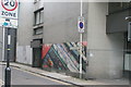
View of street art on Weyhill Road from Commercial Road
Looking northwest.
Image: © Robert Lamb
Taken: 20 Mar 2016
0.04 miles
4
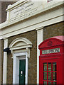
London Proof House
The Worshipful Company of Gunmakers is an ancient livery company banished from the City of London due to the hazardous nature of their trade. This is one of two proof houses in Great Britain - the other is in Birmingham - to which all small arms have to be submitted for testing, to ensure that they are safe to use, prior to sale.
Image: © Stephen McKay
Taken: 9 Apr 2008
0.04 miles
5
View of Harry Gosling Primary School from Fairclough Street
Harry Gosling Primary School marks the location of the third Jack the Ripper murder, Elizabeth Stride. Looking north-northwest.
Image: © Robert Lamb
Taken: 4 May 2014
0.04 miles
6
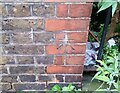
Ordnance Survey Cut Mark
This OS cut mark can be found on east side of Back Church Lane. It marks a point 14.795m above mean sea level.
Image: © Adrian Dust
Taken: 13 Nov 2021
0.05 miles
7
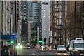
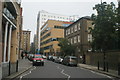
London : Tower Hamlets - Commercial Road A13
Looking along Commercial Road.
Image: © Lewis Clarke
Taken: 22 Feb 2023
0.05 miles
8
View up Batty Street from Fairclough Street
Looking north.
Image: © Robert Lamb
Taken: 4 May 2014
0.05 miles
9
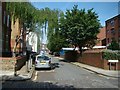
View up Back Church Lane
Looking north-northeast.
Image: © Robert Lamb
Taken: 13 Sep 2015
0.05 miles
10
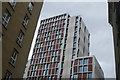
View of a new student residence block on Commercial Road from Adler Street
This somewhat attractive student residence block replaced a comparatively ugly concrete Jobcentre. Looking southeast.
Image: © Robert Lamb
Taken: 20 Mar 2016
0.06 miles