IMAGES TAKEN NEAR TO
New Road, LONDON, E1 1HJ
Introduction
This page details the photographs taken nearby to New Road, E1 1HJ by members of the Geograph project.
The Geograph project started in 2005 with the aim of publishing, organising and preserving representative images for every square kilometre of Great Britain, Ireland and the Isle of Man.

There are currently over 7.5m images from over14,400 individuals and you can help contribute to the project by visiting https://www.geograph.org.uk
Image Map
Images are licensed for reuse under creativecommons.org/licenses/by-sa/2.0
Notes
- Clicking on the map will re-center to the selected point.
- The higher the marker number, the further away the image location is from the centre of the postcode.
Image Listing (383 Images Found)
Images are licensed for reuse under creativecommons.org/licenses/by-sa/2.0
Image
Details
Distance
1
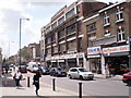
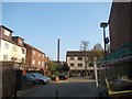
New Road, Whitechapel, London, E1 - 16-7-2009
New Road links Whitechapel Road (A11) near the Royal London Hospital with the Commercial Road (A13).
Image: © Duncan Watts
Taken: 16 Jul 2009
0.02 miles
2
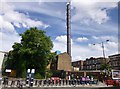
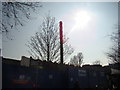
Whitechapel, chimney
Off Mount Terrace; presumably connected with the neighbouring Royal London Hospital.
Image: © Mike Faherty
Taken: 30 Jun 2012
0.02 miles
5
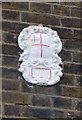
Old Boundary Marker by Mount Terrace, Stepney Parish
Estate Boundary Marker by the UC road, in parish of Stepney (Tower Hamlets District), Mount Terrace E1, on wall of No.30.
Surveyed
Milestone Society National ID: MX_CITY01em.
Image: © Milestone Society
Taken: Unknown
0.04 miles
6
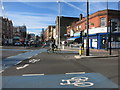
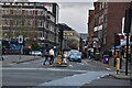
Blue Cycleway, Whitechapel Road
Not that the guy on the bike wants to use it.....
Image: © Des Blenkinsopp
Taken: 11 Feb 2016
0.04 miles
7
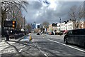
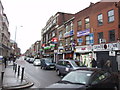
Whitechapel Road, London
The view is west to the City of London. A journey to Crystal Palace had taken an unexpected turn. Access to the subterranean Overground at Whitechapel Image being closed, passengers – sorry, customers – were recommended to board a rail replacement bus. It was a most interesting ride via Tower Bridge and Wandsworth turning south to call at the old East London line stations, Rotherhithe and Surrey Quays and the newer Canada Water before leaving us to make our own way from New Cross Gate. Every inch of the journey called for a return visit with a camera.
Photo number 7779737.
Image: © Robin Stott
Taken: 29 Mar 2024
0.04 miles
8
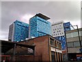
View of the new Royal London Hospital wards from Raven Row
The Royal London Hospital is currently being expanded with extra wards and the building received its "electric blue" makeover in 2008/9. I know this as this was roughly the time the Google Streetview car passed by this area: see http://www.google.co.uk/maps?f=q&source=s_q&hl=en&geocode=&q=Whitechapel+Road,+Poplar&sll=53.800651,-4.064941&sspn=20.614139,62.53418&ie=UTF8&hq=&hnear=Whitechapel+Rd,+Poplar,+Greater+London,+United+Kingdom&ll=51.51789,-0.060704&spn=0.00462,0.030534&z=16&layer=c&cbll=51.5188,-0.057594&panoid=I_phC14YLjIIHWXqHjkokw&cbp=11,64.78,,0,0.26. View taken looking west-southwest.
Image: © Robert Lamb
Taken: 19 Jun 2010
0.04 miles
9
View of the Royal London Hospital chimney from the Old Montague Street/Regal Close junction
Looking south-southeast.
Image: © Robert Lamb
Taken: 24 Mar 2012
0.04 miles
10
The Royal London Hospital Chimney, viewed from Whitechapel Road
Looking south.
Image: © Robert Lamb
Taken: 24 Mar 2012
0.04 miles