IMAGES TAKEN NEAR TO
Adler Street, LONDON, E1 1EG
Introduction
This page details the photographs taken nearby to Adler Street, E1 1EG by members of the Geograph project.
The Geograph project started in 2005 with the aim of publishing, organising and preserving representative images for every square kilometre of Great Britain, Ireland and the Isle of Man.

There are currently over 7.5m images from over14,400 individuals and you can help contribute to the project by visiting https://www.geograph.org.uk
Image Map
Images are licensed for reuse under creativecommons.org/licenses/by-sa/2.0
Notes
- Clicking on the map will re-center to the selected point.
- The higher the marker number, the further away the image location is from the centre of the postcode.
Image Listing (565 Images Found)
Images are licensed for reuse under creativecommons.org/licenses/by-sa/2.0
Image
Details
Distance
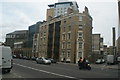
1
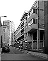
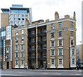
Units Workshops, 1-13 Adler Street, Whitechapel
Built in 1964 to designs by architects Yorke Rosenberg Mardall.
Image: © Jim Osley
Taken: 17 Jun 2017
0.00 miles
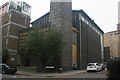
2
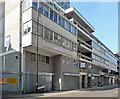
1-13 Adler Street
Brutalist. Built as flatted workshops by Yorke, Rosenberg and Mardall, 1963-64, for the London County Council, as part of post-war reconstruction.
Now largely occupied by Icon College of Technology and Management.
Image: © Stephen Richards
Taken: 4 Oct 2015
0.01 miles
3
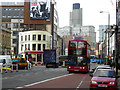
Commercial Road, Whitechapel
A bus heads out through the East End towards East Ham along Commercial Road, the western end of the A13. Tower 42, the former NatWest Tower, looms over the scene.
Image: © Stephen McKay
Taken: 9 Apr 2008
0.01 miles
4
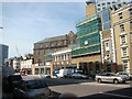
View of the Another Group Ltd building from Commercial Road
Looking north-northwest.
Image: © Robert Lamb
Taken: 4 May 2014
0.02 miles
5
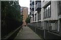
View along the path at the back of Altab Ali Park towards Adler Street
Looking north-northeast.
Image: © Robert Lamb
Taken: 13 Sep 2015
0.02 miles
6
Morrison Buildings North, 35a Commercial Road, Whitechapel
Surviving example of Victorian philanthropic housing in a rapidly changing area. Description at this https://surveyoflondon.org/map/feature/104/detail/#history.
Image: © Jim Osley
Taken: 17 Jun 2017
0.02 miles
7
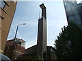
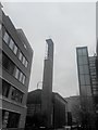
View of St. Boniface's German Church from Adler Street
The architecture of this church differs greatly from that normally seen in the UK. There is some stained glass in the roof behind the steeple but because of the angle of the image it is very hard to see! This is the Catholic German church of St Boniface's, originally built here in 1875, to serve German-speaking immigrants. German bombing in 1940 almost destroyed it. It was rebuilt in 1960 and now serves a much wider clientele within the business and tourist domains from the City and the West End. Looking south-southeast.
Image: © Robert Lamb
Taken: 4 May 2014
0.03 miles
9
View of tenement flats on Commercial Road
Looking north-northwest.
Image: © Robert Lamb
Taken: 13 Sep 2015
0.03 miles
10
View of St Boniface's German church
Looking south-southeast.
Image: © Robert Lamb
Taken: 13 Sep 2015
0.03 miles