IMAGES TAKEN NEAR TO
Norman Road, LONDON, E11 4RJ
Introduction
This page details the photographs taken nearby to Norman Road, E11 4RJ by members of the Geograph project.
The Geograph project started in 2005 with the aim of publishing, organising and preserving representative images for every square kilometre of Great Britain, Ireland and the Isle of Man.

There are currently over 7.5m images from over14,400 individuals and you can help contribute to the project by visiting https://www.geograph.org.uk
Image Map
Images are licensed for reuse under creativecommons.org/licenses/by-sa/2.0
Notes
- Clicking on the map will re-center to the selected point.
- The higher the marker number, the further away the image location is from the centre of the postcode.
Image Listing (90 Images Found)
Images are licensed for reuse under creativecommons.org/licenses/by-sa/2.0
Image
Details
Distance
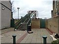
1
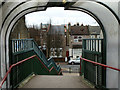
Steps down from bridge over Central Line and A12
Despite appearing fairly modern, there is no provision for those with wheels.
Image: © Robin Webster
Taken: 15 Jan 2011
0.02 miles
3
Steps up to bridge over Central Line and A12
Despite appearing fairly modern, there is no provision for those with wheels.
Image: © Robin Webster
Taken: 15 Jan 2011
0.03 miles
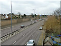
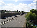
8

The A12 and Central Line
The tube and trunk road run alongside one another between Leyton and Leytonstone.
Image: © David Martin
Taken: 28 Nov 2014
0.06 miles