IMAGES TAKEN NEAR TO
Victoria Road, LONDON, E11 4JS
Introduction
This page details the photographs taken nearby to Victoria Road, E11 4JS by members of the Geograph project.
The Geograph project started in 2005 with the aim of publishing, organising and preserving representative images for every square kilometre of Great Britain, Ireland and the Isle of Man.

There are currently over 7.5m images from over14,400 individuals and you can help contribute to the project by visiting https://www.geograph.org.uk
Image Map
Images are licensed for reuse under creativecommons.org/licenses/by-sa/2.0
Notes
- Clicking on the map will re-center to the selected point.
- The higher the marker number, the further away the image location is from the centre of the postcode.
Image Listing (42 Images Found)
Images are licensed for reuse under creativecommons.org/licenses/by-sa/2.0
Image
Details
Distance
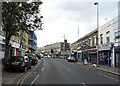
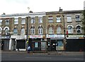
2
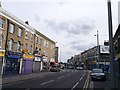
High Road Leytonstone
Part of the long road with various small shops along the road.
Image: © David Anstiss
Taken: 26 Aug 2012
0.05 miles
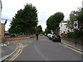
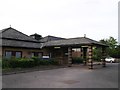
7
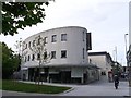
Click Internet Cafe, Leyton
Rounded modern building along Leytonstone High Road.
Image: © David Anstiss
Taken: 26 Aug 2012
0.08 miles
8
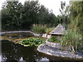
Ornamental Duck Pond, Langthorn Park
As seen from a path around the small community park.
Image: © David Anstiss
Taken: 26 Aug 2012
0.10 miles
9
Former Langthorne Hospital Building, Leyton
At the end of Union Close.
Image: © David Anstiss
Taken: 26 Aug 2012
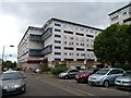
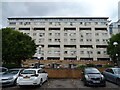
0.12 miles
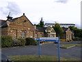
10
Former Langthorne Hospital Building, Leyton (2)
At the end of Union Close.
Image: © David Anstiss
Taken: 26 Aug 2012
0.13 miles