IMAGES TAKEN NEAR TO
Madeira Road, LONDON, E11 4AG
Introduction
This page details the photographs taken nearby to Madeira Road, E11 4AG by members of the Geograph project.
The Geograph project started in 2005 with the aim of publishing, organising and preserving representative images for every square kilometre of Great Britain, Ireland and the Isle of Man.

There are currently over 7.5m images from over14,400 individuals and you can help contribute to the project by visiting https://www.geograph.org.uk
Image Map
Images are licensed for reuse under creativecommons.org/licenses/by-sa/2.0
Notes
- Clicking on the map will re-center to the selected point.
- The higher the marker number, the further away the image location is from the centre of the postcode.
Image Listing (75 Images Found)
Images are licensed for reuse under creativecommons.org/licenses/by-sa/2.0
Image
Details
Distance
2

View of Canary Wharf from the Barking to Gospel Oak line near Leytonstone High Road station
Looking southeast across the A12 and Central line.
Image: © Robert Lamb
Taken: 21 Sep 2019
0.04 miles

4
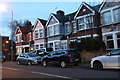
Houses on Grove Green Road, Leytonstone
Image: © David Howard
Taken: 21 Mar 2020
0.05 miles
6

The A12 and Central Line
The tube and trunk road run alongside one another between Leyton and Leytonstone.
Image: © David Martin
Taken: 28 Nov 2014
0.06 miles

9

Snow-covered houses on Dyers Hall Road
Looking west from a westbound Central line train.
Image: © Robert Lamb
Taken: 3 Dec 2010
0.07 miles
