IMAGES TAKEN NEAR TO
Kingsdown Road, LONDON, E11 3LW
Introduction
This page details the photographs taken nearby to Kingsdown Road, E11 3LW by members of the Geograph project.
The Geograph project started in 2005 with the aim of publishing, organising and preserving representative images for every square kilometre of Great Britain, Ireland and the Isle of Man.

There are currently over 7.5m images from over14,400 individuals and you can help contribute to the project by visiting https://www.geograph.org.uk
Image Map
Images are licensed for reuse under creativecommons.org/licenses/by-sa/2.0
Notes
- Clicking on the map will re-center to the selected point.
- The higher the marker number, the further away the image location is from the centre of the postcode.
Image Listing (47 Images Found)
Images are licensed for reuse under creativecommons.org/licenses/by-sa/2.0
Image
Details
Distance
1
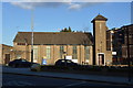
Refrigeration Spares on Harrow Road, Leyton
Image: © David Howard
Taken: 12 Nov 2017
0.12 miles
3
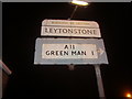
Pre-Worboys direction sign, Harrow Road Leytonstone
Image: © David Howard
Taken: 31 Jan 2009
0.14 miles
4
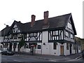
Plough and Hare Public House, Leyton
On the junction of High Road Leytonstone (in front) and Denmark Street.
Image: © David Anstiss
Taken: 26 Aug 2012
0.14 miles
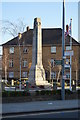
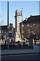
6
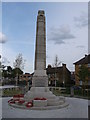
War Memorial, Leyton
On a road island at the junction of Leyton High Road, Harrow Green and Harrow Road (behind the memorial).
Image: © David Anstiss
Taken: 26 Aug 2012
0.14 miles
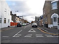
9
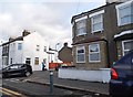
Harrow Road, Leyton
Looking towards Matcham Road
Image: © David Howard
Taken: 12 Nov 2017
0.15 miles