IMAGES TAKEN NEAR TO
Mornington Road, LONDON, E11 3EA
Introduction
This page details the photographs taken nearby to Mornington Road, E11 3EA by members of the Geograph project.
The Geograph project started in 2005 with the aim of publishing, organising and preserving representative images for every square kilometre of Great Britain, Ireland and the Isle of Man.

There are currently over 7.5m images from over14,400 individuals and you can help contribute to the project by visiting https://www.geograph.org.uk
Image Map
Images are licensed for reuse under creativecommons.org/licenses/by-sa/2.0
Notes
- Clicking on the map will re-center to the selected point.
- The higher the marker number, the further away the image location is from the centre of the postcode.
Image Listing (55 Images Found)
Images are licensed for reuse under creativecommons.org/licenses/by-sa/2.0
Image
Details
Distance
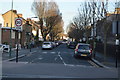
5
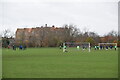
Playing Fields on Wanstead Flats
With Davies Lane Primary School in the background.
Image: © Trevor Harris
Taken: 12 Dec 2020
0.15 miles
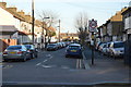
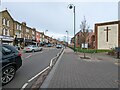
6
Michael Road, Leytonstone
A residential street in Leytonstone, East London.
Image: © Malc McDonald
Taken: 7 Jul 2011
0.15 miles
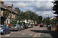
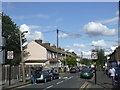
7
High Road Leytonstone at junction with Lister Road facing north with Methodist Church in view
Image: © Tom Page
Taken: 10 Feb 2022
0.15 miles
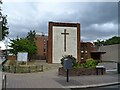
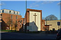
8
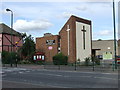
Leytonstone Methodist Church
A Methodist church in Leytonstone, East London.
Image: © Malc McDonald
Taken: 7 Jul 2011
0.16 miles
9

Path to Bush Wood
The path is known as Evelyn's Avenue.
Image: © Roger Jones
Taken: 27 Jul 2011
0.16 miles