IMAGES TAKEN NEAR TO
School Mews, LONDON, E1 0EW
Introduction
This page details the photographs taken nearby to School Mews, E1 0EW by members of the Geograph project.
The Geograph project started in 2005 with the aim of publishing, organising and preserving representative images for every square kilometre of Great Britain, Ireland and the Isle of Man.

There are currently over 7.5m images from over14,400 individuals and you can help contribute to the project by visiting https://www.geograph.org.uk
Image Map
Images are licensed for reuse under creativecommons.org/licenses/by-sa/2.0
Notes
- Clicking on the map will re-center to the selected point.
- The higher the marker number, the further away the image location is from the centre of the postcode.
Image Listing (269 Images Found)
Images are licensed for reuse under creativecommons.org/licenses/by-sa/2.0
Image
Details
Distance
1
Former shopfront in Cable Street terrace
Grade II listed : description at this https://historicengland.org.uk/listing/the-list/list-entry/1065285.
Image: © Jim Osley
Taken: 16 Sep 2017
0.03 miles
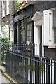
2
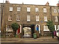
Cable Street
The Georgian terrace is listed http://www.britishlistedbuildings.co.uk/en-205809-194-224-stepney . No 220 breaks the pattern, with a mansard roof and two wide stucco bands across the facade.
Image: © Derek Harper
Taken: 1 Feb 2011
0.03 miles
4
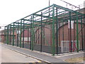
Enclosed Sports Area, Cornwall Street, E1
Image: © Danny P Robinson
Taken: 17 Sep 2009
0.03 miles
6
Hawksmoor Mews, Cable Street
A coachway entrance part way along the terrace http://www.britishlistedbuildings.co.uk/en-205809-194-224-stepney shown in Image Hawksmoor built the nearby church of St. George in the East -http://www.geograph.org.uk/search.php?i=19416940 . The blue plaque to the right records the residence here of Dr Hannah Billig, "the angel of Cable Street" (1901-1987) http://en.wikipedia.org/wiki/Hannah_Billig .
Image: © Derek Harper
Taken: 1 Feb 2011
0.03 miles
7
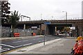
DLR crossing Cannon Street Road, London E1
DLR = Docklands Light Railway
Image: © John Salmon
Taken: 14 Oct 2008
0.04 miles
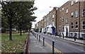
8
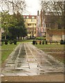
St George's Gardens
A path glistens in the rain; it leads towards Cable Street and Image, visible on the west side of the town hall.
Image: © Derek Harper
Taken: 1 Feb 2011
0.04 miles
9
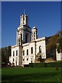
St. George in the East church
This Nicholas Hawksmoor church, designed in the early 18th century, was badly damaged in the Blitz. The interior has been completely renovated. It stands just off The Highway in Wapping.
Image: © David Williams
Taken: 9 Nov 2005
0.04 miles
10
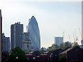
London skyline
Looking across towards the City of London with the Gherkin in the distance. The tower of St George in the East can be seen in the foreground.
Image: © Christine Matthews
Taken: 28 Apr 2009
0.04 miles