IMAGES TAKEN NEAR TO
Morieux Road, LONDON, E10 7LL
Introduction
This page details the photographs taken nearby to Morieux Road, E10 7LL by members of the Geograph project.
The Geograph project started in 2005 with the aim of publishing, organising and preserving representative images for every square kilometre of Great Britain, Ireland and the Isle of Man.

There are currently over 7.5m images from over14,400 individuals and you can help contribute to the project by visiting https://www.geograph.org.uk
Image Map
Images are licensed for reuse under creativecommons.org/licenses/by-sa/2.0
Notes
- Clicking on the map will re-center to the selected point.
- The higher the marker number, the further away the image location is from the centre of the postcode.
Image Listing (85 Images Found)
Images are licensed for reuse under creativecommons.org/licenses/by-sa/2.0
Image
Details
Distance
4

Edward VII postbox on Lea Bridge Road
Outside the former Post Office.
Postbox No. E10 24.
Image: © JThomas
Taken: 5 Aug 2017
0.07 miles
5
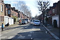
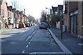
Bloxhall Road, near Leyton
Bloxhall Road is a residential street near Leyton, in the suburbs of north east London.
Image: © Malc McDonald
Taken: 3 Jun 2018
0.07 miles
7
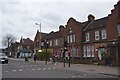
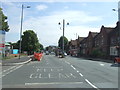
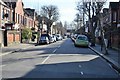
Lea Bridge Road
There are several rows of houses of this design along this stretch of the road.
Image: © Trevor Harris
Taken: 23 Feb 2025
0.08 miles