IMAGES TAKEN NEAR TO
Elizabeth Mews, LONDON, E10 5UD
Introduction
This page details the photographs taken nearby to Elizabeth Mews, E10 5UD by members of the Geograph project.
The Geograph project started in 2005 with the aim of publishing, organising and preserving representative images for every square kilometre of Great Britain, Ireland and the Isle of Man.

There are currently over 7.5m images from over14,400 individuals and you can help contribute to the project by visiting https://www.geograph.org.uk
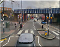
Image Map
Images are licensed for reuse under creativecommons.org/licenses/by-sa/2.0
Notes
- Clicking on the map will re-center to the selected point.
- The higher the marker number, the further away the image location is from the centre of the postcode.
Image Listing (84 Images Found)
Images are licensed for reuse under creativecommons.org/licenses/by-sa/2.0
Image
Details
Distance
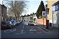
5

View of a car and mechanic mural on the side of 1 Stop Tyres on High Road Leyton
Looking south-southeast.
Image: © Robert Lamb
Taken: 27 Sep 2020
0.04 miles
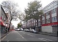
6
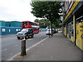
Leyton High Road
Just south of Leyton Midland Road station.
Image: © Christine Johnstone
Taken: 20 Aug 2010
0.04 miles
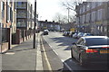
7
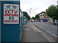
Warning in E10
A strongly-fenced development site on Leyton High Road.
Image: © Christine Johnstone
Taken: 20 Aug 2010
0.05 miles
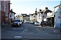
10
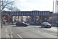
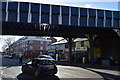
From the 97 bus, Leyton
Looking down High Road, Leyton, just north of Midland Road Overground station
Image: © Paul Harrop
Taken: 28 Mar 2024
0.06 miles