IMAGES TAKEN NEAR TO
St. Mary's Road, LONDON, E10 5RB
Introduction
This page details the photographs taken nearby to St. Mary's Road, E10 5RB by members of the Geograph project.
The Geograph project started in 2005 with the aim of publishing, organising and preserving representative images for every square kilometre of Great Britain, Ireland and the Isle of Man.

There are currently over 7.5m images from over14,400 individuals and you can help contribute to the project by visiting https://www.geograph.org.uk
Image Map
Images are licensed for reuse under creativecommons.org/licenses/by-sa/2.0
Notes
- Clicking on the map will re-center to the selected point.
- The higher the marker number, the further away the image location is from the centre of the postcode.
Image Listing (145 Images Found)
Images are licensed for reuse under creativecommons.org/licenses/by-sa/2.0
Image
Details
Distance
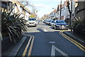
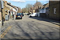
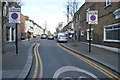
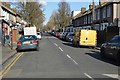
5
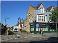
St Mary's Road, Leyton
St Mary's Road in Leyton, in the suburbs of north east London, at its junction with Leyton High Road. The "no entry" road signs prohibit vehicles from entering St Mary's Road at this junction.
Image: © Malc McDonald
Taken: 31 May 2021
0.07 miles
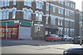
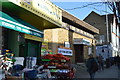
6
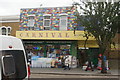
View of the brightly coloured facade of Carnival Cards and Gifts from Leyton High Street
Looking northeast.
Image: © Robert Lamb
Taken: 29 Aug 2020
0.07 miles