IMAGES TAKEN NEAR TO
Church Road, LONDON, E10 5JU
Introduction
This page details the photographs taken nearby to Church Road, E10 5JU by members of the Geograph project.
The Geograph project started in 2005 with the aim of publishing, organising and preserving representative images for every square kilometre of Great Britain, Ireland and the Isle of Man.

There are currently over 7.5m images from over14,400 individuals and you can help contribute to the project by visiting https://www.geograph.org.uk
Image Map
Images are licensed for reuse under creativecommons.org/licenses/by-sa/2.0
Notes
- Clicking on the map will re-center to the selected point.
- The higher the marker number, the further away the image location is from the centre of the postcode.
Image Listing (112 Images Found)
Images are licensed for reuse under creativecommons.org/licenses/by-sa/2.0
Image
Details
Distance
1
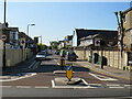
Grange Park Road, Leyton
The northern part of Grange Park Road is a minor residential street. Compare this with image Image taken from the same spot but looking in the opposite direction.
Image: © Malc McDonald
Taken: 31 May 2021
0.05 miles
2
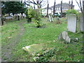
In St Mary's Churchyard, Leyton
Domesday Book records two priests in Leyton in 1086, so the current church almost certainly occupies the site of a much earlier building. The red brick tower of St Mary the Virgin, Leyton dates from 1658. It has an 18th century clock turret on top. Other parts date from the 17th and 19th centuries, although the church was much altered and enlarged in 1932.
Ian Nairn in Nairn's London (1966) says of Leyton Church: "A huge surprise in the endless late-Victorian bow fronts of London-across-the-Lea. A village church that gradually got bigger, and one that has never been rectified. A pre-war west porch adds itself unselfconsciously to the bits of 1830 and 1750, all shapes and sizes, as diverse as the characters in a saloon bar. This is something far more important than architectural style, and the kind of thing that was swept away in ninety-nine cases out of a hundred for the sake of 'correctness' or 'tidyness' - like cutting inches off people's heads to make things consistent."
The churchyard is certainly like a country churchyard dropped down into densely-packed east London. The northern half is maintained as a nature reserve, although the whole is of great ecological and historical interest.
In this view, the houses beyond the churchyard are in Goldsmith Road.
Image: © Marathon
Taken: 7 Jan 2015
0.05 miles
3
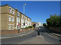
Grange Park Road, Leyton
This stretch of Grange Park Road, in the north east London suburbs, is a one-way street forming part of the route of the A112 road.
Image: © Malc McDonald
Taken: 31 May 2021
0.05 miles
5
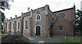
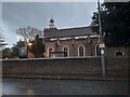
St Mary with St Edward & St Luke, Church Road, Leyton
Image: © John Salmon
Taken: 17 Sep 2011
0.06 miles
6
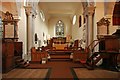
St Mary with St Edward & St Luke, Church Road, Leyton - East end
Image: © John Salmon
Taken: 17 Sep 2011
0.06 miles
7
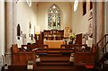
St Mary with St Edward & St Luke, Church Road, Leyton - Chancel
Image: © John Salmon
Taken: 17 Sep 2011
0.06 miles
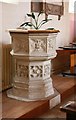
8
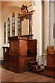
St Mary with St Edward & St Luke, Church Road, Leyton - Pulpit
Image: © John Salmon
Taken: 17 Sep 2011
0.06 miles
9
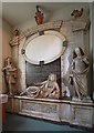
St Mary with St Edward & St Luke, Church Road, Leyton - Monument
Image: © John Salmon
Taken: 17 Sep 2011
0.06 miles
10
St Mary with St Edward & St Luke, Church Road, Leyton - Font
Image: © John Salmon
Taken: 17 Sep 2011
0.06 miles