IMAGES TAKEN NEAR TO
Mearse Lane, STOURBRIDGE, DY9 9YG
Introduction
This page details the photographs taken nearby to Mearse Lane, DY9 9YG by members of the Geograph project.
The Geograph project started in 2005 with the aim of publishing, organising and preserving representative images for every square kilometre of Great Britain, Ireland and the Isle of Man.

There are currently over 7.5m images from over14,400 individuals and you can help contribute to the project by visiting https://www.geograph.org.uk
Image Map (Loading...)


Getting Data...Please wait
Leaflet Map data © OpenStreetMap
Images are licensed for reuse under creativecommons.org/licenses/by-sa/2.0
Notes
- Clicking on the map will re-center to the selected point.
- The higher the marker number, the further away the image location is from the centre of the postcode.
Image Listing (6 Images Found)
Images are licensed for reuse under creativecommons.org/licenses/by-sa/2.0
Image
Details
Distance
1
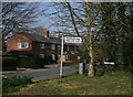
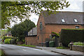
Mearse Lane
Junction of the B4188 and Mearse Lane, Hartle
Image: © Geoff Gartside
Taken: 1 Apr 2007
0.01 miles
6
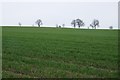
Farmland near Hagley Hill Farm
Farmland near Hagley Hill Farm to the south of Mearse Lane. This appears to be a field of spring barley or wheat.
Image: © Philip Halling
Taken: 5 Apr 2018
0.21 miles