IMAGES TAKEN NEAR TO
Chapel Lane, STOURBRIDGE, DY9 9XJ
Introduction
This page details the photographs taken nearby to Chapel Lane, DY9 9XJ by members of the Geograph project.
The Geograph project started in 2005 with the aim of publishing, organising and preserving representative images for every square kilometre of Great Britain, Ireland and the Isle of Man.

There are currently over 7.5m images from over14,400 individuals and you can help contribute to the project by visiting https://www.geograph.org.uk
Image Map
Images are licensed for reuse under creativecommons.org/licenses/by-sa/2.0
Notes
- Clicking on the map will re-center to the selected point.
- The higher the marker number, the further away the image location is from the centre of the postcode.
Image Listing (6 Images Found)
Images are licensed for reuse under creativecommons.org/licenses/by-sa/2.0
Image
Details
Distance
1
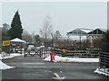
Beechcroft Nurseries and Garden Centre
Viewed from across Madeley Road, Belbroughton.
Image: © Jonathan Billinger
Taken: 14 Jan 2010
0.16 miles
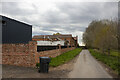
2
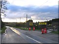
Beechcroft Garden Centre, Madeley Lane
This garden centre is on Madeley Lane. The cross-roads just ahead are with Chapel Lane, on the right and Bonfire Hill on the left.
Image: © Roy Hughes
Taken: 13 Jan 2009
0.17 miles
5
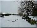
Beechcroft Nurseries car park
The production houses of the nursery can be seen beyond the hedge to the left.
Image: © Jonathan Billinger
Taken: 14 Jan 2010
0.22 miles