IMAGES TAKEN NEAR TO
Heath End Road, STOURBRIDGE, DY9 9XH
Introduction
This page details the photographs taken nearby to Heath End Road, DY9 9XH by members of the Geograph project.
The Geograph project started in 2005 with the aim of publishing, organising and preserving representative images for every square kilometre of Great Britain, Ireland and the Isle of Man.

There are currently over 7.5m images from over14,400 individuals and you can help contribute to the project by visiting https://www.geograph.org.uk
Image Map (Loading...)


Getting Data...Please wait
Leaflet Map data © OpenStreetMap
Images are licensed for reuse under creativecommons.org/licenses/by-sa/2.0
Notes
- Clicking on the map will re-center to the selected point.
- The higher the marker number, the further away the image location is from the centre of the postcode.
Image Listing (7 Images Found)
Images are licensed for reuse under creativecommons.org/licenses/by-sa/2.0
Image
Details
Distance
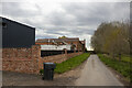
2
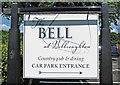
The Bell at Belbroughton (3) - car park sign, Bell End
The entrance to the car park is off Heath End Road. This sign is by the entrance but inside the car park.
Image
Image
Image: © P L Chadwick
Taken: 16 Jul 2011
0.23 miles
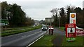
3
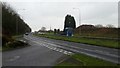
A491 Stourbridge Road
Looking south-west towards Stoneybridge.
Image: © Jonathan Billinger
Taken: 20 Nov 2018
0.24 miles
4
Belbroughton : Stourbridge Road A491
Looking along Stourbridge Road.
Image: © Lewis Clarke
Taken: 29 Sep 2019
0.24 miles
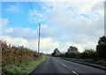
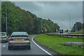
6
A491 Stourbridge Road
Looking NE towards the Romsley turn.
Image: © Jonathan Billinger
Taken: 20 Nov 2018
0.25 miles