IMAGES TAKEN NEAR TO
Woodfield Lane, STOURBRIDGE, DY9 9UT
Introduction
This page details the photographs taken nearby to Woodfield Lane, DY9 9UT by members of the Geograph project.
The Geograph project started in 2005 with the aim of publishing, organising and preserving representative images for every square kilometre of Great Britain, Ireland and the Isle of Man.

There are currently over 7.5m images from over14,400 individuals and you can help contribute to the project by visiting https://www.geograph.org.uk
Image Map
Images are licensed for reuse under creativecommons.org/licenses/by-sa/2.0
Notes
- Clicking on the map will re-center to the selected point.
- The higher the marker number, the further away the image location is from the centre of the postcode.
Image Listing (10 Images Found)
Images are licensed for reuse under creativecommons.org/licenses/by-sa/2.0
Image
Details
Distance
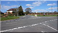
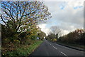
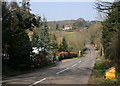
2
Woodfield Lane Approaching Crossroads Bell Heath
Image: © Roy Hughes
Taken: 21 Mar 2017
0.06 miles
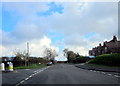
5
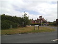
Farley Lane
The view of the crossroads at Bell Heath.
Image: © Gordon Griffiths
Taken: 21 Jul 2013
0.06 miles
6
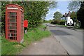
Telephone box at Bell Heath
Telephone box at Bell Heath beside Quantry Lane. I don't think there is a telephone in the phone bax anymore.
Image: © Philip Halling
Taken: 26 Apr 2018
0.07 miles
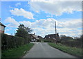
9
Madeley Heath
Steep down and up through Madeley Heath towards a fiveways at Bell Heath
Image: © Geoff Gartside
Taken: 1 Apr 2007
0.13 miles
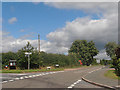
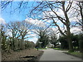
10
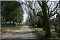
Woodfield Lane
Road from Sling Common towards Bell Heath
Image: © Geoff Gartside
Taken: 1 Apr 2007
0.22 miles