IMAGES TAKEN NEAR TO
Gorse Green Lane, STOURBRIDGE, DY9 9UN
Introduction
This page details the photographs taken nearby to Gorse Green Lane, DY9 9UN by members of the Geograph project.
The Geograph project started in 2005 with the aim of publishing, organising and preserving representative images for every square kilometre of Great Britain, Ireland and the Isle of Man.

There are currently over 7.5m images from over14,400 individuals and you can help contribute to the project by visiting https://www.geograph.org.uk
Image Map
Images are licensed for reuse under creativecommons.org/licenses/by-sa/2.0
Notes
- Clicking on the map will re-center to the selected point.
- The higher the marker number, the further away the image location is from the centre of the postcode.
Image Listing (8 Images Found)
Images are licensed for reuse under creativecommons.org/licenses/by-sa/2.0
Image
Details
Distance
1
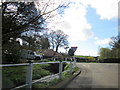
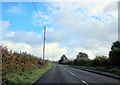
Shut Mill Lane Junction With Gorse Green Lane Sling Common
Image: © Roy Hughes
Taken: 21 Mar 2017
0.02 miles
2
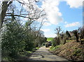
Shut Mill Lane Approaching Gorse Green Lane Sling Common
Image: © Roy Hughes
Taken: 21 Mar 2017
0.05 miles
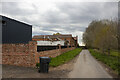
4
Shut Mill Lane View
The Lane view in the Clent Hills, Worcestershire.
Image: © Gordon Griffiths
Taken: 26 Aug 2012
0.13 miles
5
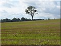
Tree in a stubble field
Tree in a stubble field to the north of Bell End.
Image: © Philip Halling
Taken: 19 Sep 2017
0.14 miles
6
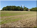
Shut Coppice
View to Shut Coppice across a stubble field to the north of Bell End.
Image: © Philip Halling
Taken: 19 Sep 2017
0.19 miles
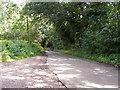
8
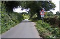
Gorse Green Lane Narrows
The view near Bell End.
Image: © Gordon Griffiths
Taken: 26 Aug 2012
0.23 miles