IMAGES TAKEN NEAR TO
Hartle Lane, STOURBRIDGE, DY9 9UL
Introduction
This page details the photographs taken nearby to Hartle Lane, DY9 9UL by members of the Geograph project.
The Geograph project started in 2005 with the aim of publishing, organising and preserving representative images for every square kilometre of Great Britain, Ireland and the Isle of Man.

There are currently over 7.5m images from over14,400 individuals and you can help contribute to the project by visiting https://www.geograph.org.uk
Image Map (Loading...)


Getting Data...Please wait
Leaflet Map data © OpenStreetMap
Images are licensed for reuse under creativecommons.org/licenses/by-sa/2.0
Notes
- Clicking on the map will re-center to the selected point.
- The higher the marker number, the further away the image location is from the centre of the postcode.
Image Listing (11 Images Found)
Images are licensed for reuse under creativecommons.org/licenses/by-sa/2.0
Image
Details
Distance
1
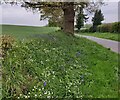
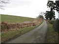
Mearse Lane, Belbroughton
Seven years on, an update to Image The footpath sign is still clearly visible. Narrow country lanes don't change much.
Image: © Mike Dodman
Taken: 11 Oct 2016
0.20 miles
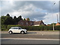
3
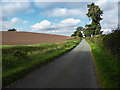
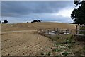
Mearse Lane
Looking towards Belbroughton from near Hagley Hill Farm.
Image: © Richard Webb
Taken: 15 Feb 2009
0.23 miles
4
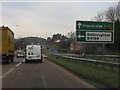
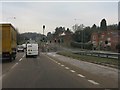
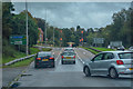
A491 approaching Hartle Lane traffic lights
Image: © Peter Whatley
Taken: 17 Jan 2012
0.23 miles
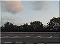
8
Belbroughton : Stourbridge Road A491
Looking along the road through Bell End.
Image: © Lewis Clarke
Taken: 29 Sep 2019
0.24 miles