IMAGES TAKEN NEAR TO
Bromsgrove Road, STOURBRIDGE, DY9 9QD
Introduction
This page details the photographs taken nearby to Bromsgrove Road, DY9 9QD by members of the Geograph project.
The Geograph project started in 2005 with the aim of publishing, organising and preserving representative images for every square kilometre of Great Britain, Ireland and the Isle of Man.

There are currently over 7.5m images from over14,400 individuals and you can help contribute to the project by visiting https://www.geograph.org.uk
Image Map (Loading...)


Getting Data...Please wait
Leaflet Map data © OpenStreetMap
Images are licensed for reuse under creativecommons.org/licenses/by-sa/2.0
Notes
- Clicking on the map will re-center to the selected point.
- The higher the marker number, the further away the image location is from the centre of the postcode.
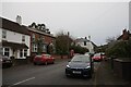
Image Listing (21 Images Found)
Images are licensed for reuse under creativecommons.org/licenses/by-sa/2.0
Image
Details
Distance

2
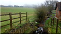
Odnall Brook
One of many small streams emanating from the Clent Hills spring line.
Image: © Jonathan Billinger
Taken: 17 Jan 2017
0.03 miles
3
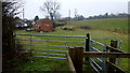
Kissing gate by Old Mill Farm
Yes that is an MG Midget languishing in the grass by the shed.
Image: © Jonathan Billinger
Taken: 17 Jan 2017
0.05 miles
10
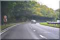
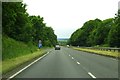
Clent : Stourbridge Road A491
Looking along Stourbridge Road through Clent.
Image: © Lewis Clarke
Taken: 29 Sep 2019
0.18 miles