IMAGES TAKEN NEAR TO
St. Kenelms Pass, STOURBRIDGE, DY9 9PE
Introduction
This page details the photographs taken nearby to St. Kenelms Pass, DY9 9PE by members of the Geograph project.
The Geograph project started in 2005 with the aim of publishing, organising and preserving representative images for every square kilometre of Great Britain, Ireland and the Isle of Man.

There are currently over 7.5m images from over14,400 individuals and you can help contribute to the project by visiting https://www.geograph.org.uk
Image Map
Images are licensed for reuse under creativecommons.org/licenses/by-sa/2.0
Notes
- Clicking on the map will re-center to the selected point.
- The higher the marker number, the further away the image location is from the centre of the postcode.
Image Listing (24 Images Found)
Images are licensed for reuse under creativecommons.org/licenses/by-sa/2.0
Image
Details
Distance
1
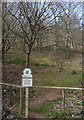
Pathway to Clent Hills
Just outside the village of Clent
Image: © Geoff Gartside
Taken: 7 Apr 2007
0.03 miles
2
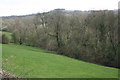
Looking towards Walton Hill, near Clent
Image: © Geoff Gartside
Taken: 7 Apr 2007
0.08 miles
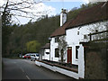
3
Misty Clent Hills
An old ruined building by St. Kenelm's Pass road.
Image: © Jonathan Billinger
Taken: 17 Jan 2017
0.12 miles
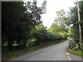
5
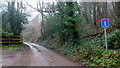
Clatterbach Lane
A short dead-end lane off St. Kenelm's Pass, Clent Hills.
Image: © Jonathan Billinger
Taken: 17 Jan 2017
0.15 miles
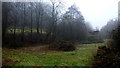
6
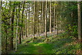
In Deep Wood
Woodland on the southern slope of Clent Hill.
Image: © Phil Champion
Taken: 21 Apr 2014
0.16 miles
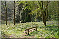
10
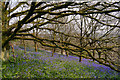
Bluebells on the southern slopes of Clent Hill
Image: © Phil Champion
Taken: 21 Apr 2014
0.19 miles