IMAGES TAKEN NEAR TO
Dobbins Oak Road, STOURBRIDGE, DY9 9JB
Introduction
This page details the photographs taken nearby to Dobbins Oak Road, DY9 9JB by members of the Geograph project.
The Geograph project started in 2005 with the aim of publishing, organising and preserving representative images for every square kilometre of Great Britain, Ireland and the Isle of Man.

There are currently over 7.5m images from over14,400 individuals and you can help contribute to the project by visiting https://www.geograph.org.uk
Image Map (Loading...)


Getting Data...Please wait
Leaflet Map data © OpenStreetMap
Images are licensed for reuse under creativecommons.org/licenses/by-sa/2.0
Notes
- Clicking on the map will re-center to the selected point.
- The higher the marker number, the further away the image location is from the centre of the postcode.
Image Listing (11 Images Found)
Images are licensed for reuse under creativecommons.org/licenses/by-sa/2.0
Image
Details
Distance
1
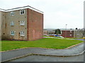
Flats off Dobbins Oak Road
Compare and contrast with Image in the same gridsquare.
Image: © Jonathan Billinger
Taken: 22 Mar 2010
0.03 miles
2
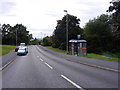
Dobbin's Oak Road Bus Stop
The view down Gauden Road near Pedmore, Dudley.
Image: © Gordon Griffiths
Taken: 20 Aug 2011
0.08 miles
3
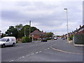
Gauden Road
The view up the Dudley street from the junction with Wychbury Road.
Image: © Gordon Griffiths
Taken: 20 Aug 2011
0.10 miles
4
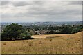
The Black Country viewed from Wychbury Hill
The Black Country is an area of the West Midlands covering most of the Metropolitan Boroughs of Dudley, Sandwell and Walsall. The name dates from the 1840s, and is believed to come from the soot that the heavy industries covered the area in.
Wychbury Hill is part of the Clent Hills, it lies on the border of West Midlands and Worcestershire. Its highest point is 224 m (735 ft) above sea level.
Image: © Mat Fascione
Taken: 23 Jul 2022
0.15 miles
5
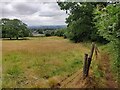
Monarch's Way at Wychbury Hill
Wychbury Hill is part of the Clent Hills, it lies on the border of West Midlands and Worcestershire. Its highest point is 224 m (735 ft) above sea level.
Image: © Mat Fascione
Taken: 23 Jul 2022
0.19 miles
6
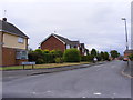
Wythwood Close
The view down the Pedmore street.
Image: © Gordon Griffiths
Taken: 20 Aug 2011
0.20 miles
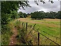
7
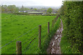
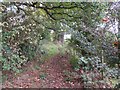
Path to Pedmore
This path leads down from Wychbury Hill past Pedmore Hall Farm. Underfoot conditions are muddy.
Image: © Stephen McKay
Taken: 25 Apr 2018
0.21 miles
8
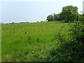
Hodgehole Dingle
The view off Pedmore Lane.
Image: © Gordon Griffiths
Taken: 27 Apr 2007
0.21 miles
9
Monarch's Way at Wychbury Hill
Wychbury Hill is part of the Clent Hills, it lies on the border of West Midlands and Worcestershire. Its highest point is 224 m (735 ft) above sea level.
Image: © Mat Fascione
Taken: 23 Jul 2022
0.23 miles