IMAGES TAKEN NEAR TO
Crabbe Street, STOURBRIDGE, DY9 8TQ
Introduction
This page details the photographs taken nearby to Crabbe Street, DY9 8TQ by members of the Geograph project.
The Geograph project started in 2005 with the aim of publishing, organising and preserving representative images for every square kilometre of Great Britain, Ireland and the Isle of Man.

There are currently over 7.5m images from over14,400 individuals and you can help contribute to the project by visiting https://www.geograph.org.uk
Image Map
Images are licensed for reuse under creativecommons.org/licenses/by-sa/2.0
Notes
- Clicking on the map will re-center to the selected point.
- The higher the marker number, the further away the image location is from the centre of the postcode.
Image Listing (30 Images Found)
Images are licensed for reuse under creativecommons.org/licenses/by-sa/2.0
Image
Details
Distance
1
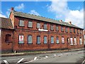
Old Factory - Crabbe Street Lye/Wollescote
This historic factory building is located close to the junction of Crabbe Street and Balds Lane.
Image: © Kieron McMahon
Taken: 1 Apr 2004
0.05 miles
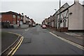
2

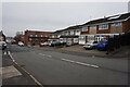
Former Red Lion public house, Careless Green, Stourbridge
Now J & L Electrics.
Image: © Ian S
Taken: 17 Dec 2021
0.10 miles
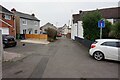
3

Former Red Lion public house, Careless Green, Stourbridge
Now J & L Electrics.
Image: © Ian S
Taken: 17 Dec 2021
0.11 miles
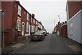
10
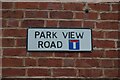
Park View Road off Careless Green, Stourbridge
Image: © Ian S
Taken: 17 Dec 2021
0.15 miles