IMAGES TAKEN NEAR TO
Belmont Road, STOURBRIDGE, DY9 8AS
Introduction
This page details the photographs taken nearby to Belmont Road, DY9 8AS by members of the Geograph project.
The Geograph project started in 2005 with the aim of publishing, organising and preserving representative images for every square kilometre of Great Britain, Ireland and the Isle of Man.

There are currently over 7.5m images from over14,400 individuals and you can help contribute to the project by visiting https://www.geograph.org.uk
Image Map
Images are licensed for reuse under creativecommons.org/licenses/by-sa/2.0
Notes
- Clicking on the map will re-center to the selected point.
- The higher the marker number, the further away the image location is from the centre of the postcode.
Image Listing (57 Images Found)
Images are licensed for reuse under creativecommons.org/licenses/by-sa/2.0
Image
Details
Distance
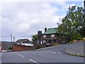
1

Top Bell public house, Belmont Road, Stourbridge
Image: © Ian S
Taken: 17 Dec 2021
0.03 miles
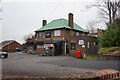
2
Top Bell
The view of the Pub on Hill Bank in Lye, Dudley.
Image: © Gordon Griffiths
Taken: 11 Jun 2017
0.03 miles
4
Top Bell public house, Belmont Road, Stourbridge
Image: © Ian S
Taken: 17 Dec 2021
0.03 miles
5
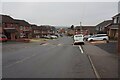
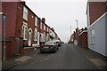
Belmont Road towards Cemetery Road, Stourbridge
Image: © Ian S
Taken: 17 Dec 2021
0.04 miles
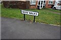
6
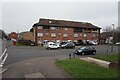
Flats on Cross Walks off Belmont Road, Stourbridge
Image: © Ian S
Taken: 17 Dec 2021
0.04 miles
10
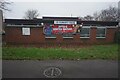
Lye Community Centre
On Cross Walks, Stourbridge.
Image: © Ian S
Taken: 17 Dec 2021
0.11 miles