IMAGES TAKEN NEAR TO
Brockmoor Close, STOURBRIDGE, DY9 0YL
Introduction
This page details the photographs taken nearby to Brockmoor Close, DY9 0YL by members of the Geograph project.
The Geograph project started in 2005 with the aim of publishing, organising and preserving representative images for every square kilometre of Great Britain, Ireland and the Isle of Man.

There are currently over 7.5m images from over14,400 individuals and you can help contribute to the project by visiting https://www.geograph.org.uk
Image Map
Images are licensed for reuse under creativecommons.org/licenses/by-sa/2.0
Notes
- Clicking on the map will re-center to the selected point.
- The higher the marker number, the further away the image location is from the centre of the postcode.
Image Listing (13 Images Found)
Images are licensed for reuse under creativecommons.org/licenses/by-sa/2.0
Image
Details
Distance
1
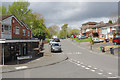
Chawn Park Drive, Stourbridge
Thicknall Drive leads off to the left by a small row of shops including Chapter One Barbers. The houses on the right hand side of the road are of an unusual design.
Image: © Stephen McKay
Taken: 25 Apr 2018
0.06 miles
2
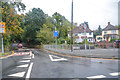
Stourbridge : Old Ham Lane
Looking along Old Ham Lane in Stourbridge.
Image: © Lewis Clarke
Taken: 29 Sep 2019
0.07 miles
3
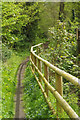
Footpath to Wollescote
The public footpath sign (out of shot) indicates that this leads to Wollescote (one mile). Most people probably prefer to use it for a pleasant stroll through Ham Dingle.
Image: © Stephen McKay
Taken: 25 Apr 2018
0.08 miles
4
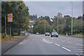
Stourbridge : Ham Lane
Looking along Ham Lane in the Pedmore and Stourbridge East area.
Image: © Lewis Clarke
Taken: 29 Sep 2019
0.11 miles
5
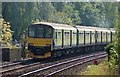
Class 150 Near Stourbridge Junction
A Class 150 diesel multiple unit [with No 150116 nearest the camera] has just left the south end of Stourbridge Junction station en route to Hagley, Blakedown and Kidderminster
Image: © Rob Newman
Taken: 14 Oct 2011
0.19 miles
6
Doctors Hill, Stourbridge
Looking up from Chawn Park Drive to the oddly-named Doctors Hill. The houses here are of an unusual style and the bin lorry is evidently awaited (or has very recently been). The wooded top of Wychbury Hill can be seen in the distance.
Image: © Stephen McKay
Taken: 25 Apr 2018
0.19 miles
7
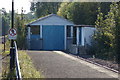
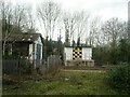
Shed for Local Trains at Stourbridge Junction
The small shed at the south end of the station at Stourbridge Town which houses the two Class 139 vehicles which work the Stourbridge Town branch
Image: © Rob Newman
Taken: 14 Oct 2011
0.20 miles
8
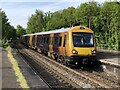
Class 172 Multiple Unit at Stourbridge Junction
A West Midlands Railway service from Worcester Foregate Street to Whitlocks End arriving into Stourbridge Junction.
Image: © David Robinson
Taken: 18 May 2023
0.21 miles
9
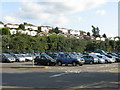
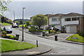
Houses on Chawn Hill
Taken from the car park of Stourbridge Junction station, the houses nearest are on Lutley Drive, while those on the crest are on Chawn Park Drive.
Image: © Peter Whatley
Taken: 13 Sep 2008
0.21 miles
10
Buildings near Stourbridge Junction Railway Station
Image: © JThomas
Taken: 14 Apr 2023
0.21 miles