IMAGES TAKEN NEAR TO
Haybridge Mews, STOURBRIDGE, DY9 0GJ
Introduction
This page details the photographs taken nearby to Haybridge Mews, DY9 0GJ by members of the Geograph project.
The Geograph project started in 2005 with the aim of publishing, organising and preserving representative images for every square kilometre of Great Britain, Ireland and the Isle of Man.

There are currently over 7.5m images from over14,400 individuals and you can help contribute to the project by visiting https://www.geograph.org.uk
Image Map (Loading...)


Getting Data...Please wait
Leaflet Map data © OpenStreetMap
Images are licensed for reuse under creativecommons.org/licenses/by-sa/2.0
Notes
- Clicking on the map will re-center to the selected point.
- The higher the marker number, the further away the image location is from the centre of the postcode.
Image Listing (53 Images Found)
Images are licensed for reuse under creativecommons.org/licenses/by-sa/2.0
Image
Details
Distance
4
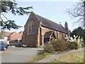
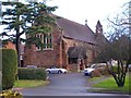
St Saviours Church
Built in 1908 to cater for the expanding population of West Hagley.
Image: © John M
Taken: 21 Mar 2009
0.08 miles
10
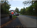
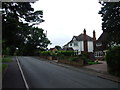
Park Road Lights
The lights at the junction with Worcester Road in Hagley.
Image: © Gordon Griffiths
Taken: 8 Oct 2011
0.10 miles